


Geo-ICT helps collect, manage, and analyze location-based data for the design, construction, management, and maintenance of infrastructure.

Infrastructure is the backbone of our society. Think of power grids, water mains, roads, railways, fiber-optic networks, and industrial facilities. These networks are becoming increasingly complex and generate enormous amounts of data. To manage that information effectively, Geo-ICT is becoming increasingly important.
Geo-ICT combines geographic information, data analysis, and information technology. This enables organizations to better design, build, manage, and maintain infrastructure. Within the infrastructure sector, Geo-ICT therefore plays a central role in virtually every phase of a project.
Definition:
Geo-ICT is the field in which geographic information is combined with information technology. It revolves around the collection, management, analysis, and visualization of location-based data.
Whereas traditional databases primarily store data, Geo-ICT adds an extra dimension: location. This reveals where objects are located and how they relate to one another.
A Geographic Information System (GIS) forms the basis of many Geo-ICT applications. GIS software enables organizations to manage and analyze geographic data.
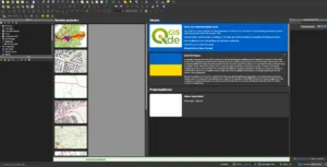
The best-known open-source GIS platform is QGIS. This system makes it possible to combine different data sources into a single, easy-to-navigate map environment.
A GIS can, for example, provide insight into:
Geo-ICT utilizes a variety of data sources. In the Netherlands, the following registries are among the most important sources:
Combining these datasets provides a complete picture of the physical environment.
Modern infrastructure projects are complex. Underground cables, pipelines, buildings, nature areas, property boundaries, and permitting processes all come together within a single project.
Geo-ICT helps organize this information and identify risks early on.
Network operators such as Alliander, Stedin, and Enexis manage hundreds of thousands of kilometers of cables and pipelines. Without up-to-date geographic information, it becomes virtually impossible to manage these networks efficiently.
With GIS, organizations can see exactly:
This allows work to be planned and carried out more efficiently.
Geo-ICT supports not only operational processes but also strategic decision-making.
For example, spatial analyses enable organizations to determine:
This leads to more informed investment decisions.

The added value of Geo-ICT begins well before the first shovel hits the ground.
During the design phase, geographic information is used to develop technical solutions that fit within the available space and existing infrastructure.
When constructing new infrastructure, existing networks, property lines, nature areas, and buildings must be taken into account.
GIS helps engineers with:
This helps minimize errors and unexpected costs during construction.
In modern infrastructure projects, various disciplines work together.
CAD software such as AutoCAD is used for technical designs. GIS provides the geographic context. BIM models add detailed information about objects and structures.
Combining these systems creates a comprehensive view of the project.
This enables engineers to collaborate more quickly and make better-informed decisions.
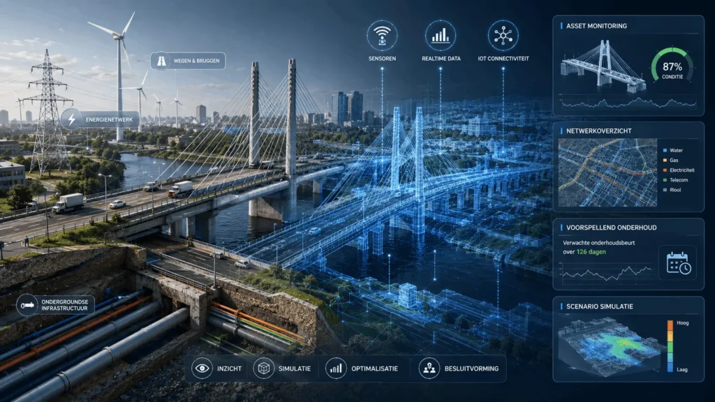
More and more organizations are developing digital twins of infrastructure.
A Digital Twin combines geographic data, sensor data, and technical models into a single digital environment.
This enables organizations to:
Geo-ICT also plays an important role during implementation.
Project teams use geographic data to guide their work and track progress.
Using GNSS equipment and mobile GIS solutions, employees can collect data directly in the field.
This results in an up-to-date record of:
This information is immediately available to other stakeholders involved in the project.
After completion, completed structures must be accurately documented.
This as-built data forms the basis for future management and maintenance.
An up-to-date asset database prevents errors and increases the reliability of infrastructure data.
The greatest value of Geo-ICT often emerges after a project has been completed.
Management organizations use geographic information on a daily basis to manage assets and plan maintenance.
Asset management revolves around the optimal management of physical objects throughout their entire lifecycle.
GIS supports this by providing insight into:
This enables organizations to deploy their resources more efficiently.
Traditional maintenance is performed at fixed intervals.
Organizations are increasingly switching to predictive maintenance.
By combining geographic data with sensor data and historical failure records, risks can be better predicted.
This reduces downtime and lowers maintenance costs.
New technologies are driving rapid development in Geo-ICT.
Digital Twins make it possible to monitor infrastructure in real time.
By linking real-time data to digital models, we gain continuous insight into asset performance.
This supports:
Artificial intelligence is increasingly being applied within Geo-ICT.
GeoAI can analyze large amounts of geographic data and recognize patterns that are difficult for humans to detect.
Drones and IoT sensors are providing an ever-increasing amount of up-to-date data.
This data can be directly integrated into GIS systems, enabling organizations to respond more quickly to changes in the field.
Various software platforms are used in the infrastructure sector.
Commonly used solutions include:
GIS software often serves as the central platform for asset management and spatial analysis.
More and more organizations are opting for open-source solutions such as QGIS because of their flexibility and lower licensing costs.
Infrastructure data is often stored in multiple systems.
Using tools such as FME, PostGIS, and Python, organizations can automatically integrate, enrich, and synchronize data.
This eliminates manual work and improves data quality.
The energy transition is creating major challenges in the Netherlands.
Grid operators must expand their networks to accommodate the growth in electric vehicles, heat pumps, and renewable energy.
GIS supports:
This allows investments to be planned and implemented more effectively.
Geo-ICT plays a crucial role in modern infrastructure projects. From design and engineering to implementation, management, and maintenance, geographic information provides better insight, more efficient processes, and improved decision-making.
The combination of GIS, geodata, BIM, Digital Twins, and GeoAI creates an increasingly intelligent ecosystem in which infrastructure is not only managed but also predicted and optimized.
For organizations active in energy, telecommunications, water management, industry, or civil engineering, Geo-ICT is therefore no longer just a supporting technology, but a strategic pillar for the future.
Would you like to work with geoinformation in infrastructure? Check out the job opening for a work planner in infrastructure. We also offer courses in civil engineering, such as the Civil Engineering course.

Geo-ICT helps collect, manage, and analyze location-based data for the design, construction, management, and maintenance of infrastructure.
GIS focuses on geographic analysis and location data, while CAD is primarily used for technical designs and drawings.
Utility companies use GIS for asset management, fault analysis, maintenance planning, and network expansion.
GIS provides insight into the exact location of underground infrastructure and helps prevent damage, conflicts, and failure costs.
A digital twin is a digital representation of a physical object or network that uses real-time data for monitoring and simulations.