
Functional and technical management of CAD and (web) GIS systems
Functional and technical management of CAD and (web) GIS systems
 As an Application Administrator, you are indispensable in the world of geographic information systems. Your day is filled with a variety of tasks that are both technical and communicative in nature. Below is an overview of what you can expect in this role:
You are not only a technical expert but also a communicator who bridges the gap between technology and practice. You ensure that all users can work comfortably and competently with the systems you manage. Your expertise contributes to optimal information provision within your organization, enabling decision-making based on accurate and accessible data.
Thanks to your dedication and knowledge, the value of geoinformation within the organization is maximized, making you a key figure in achieving strategic goals. Your role is crucial to the day-to-day operations of the company, and your contribution has a major impact on the success of projects.
The work of an Application Administrator is crucial because it directly impacts the efficiency and effectiveness of geoinformation systems within an organization. Here are a few reasons why your role is so important:
You not only contribute to the technical side, but you also ensure that users can effectively navigate the systems. This increases the user-friendliness and accessibility of important geographic information. Your efforts enable teams to:
Your knowledge and skills maximize the value of geographic information, making you an indispensable link in your organization’s success. Your work ensures that everyone within the organization can do their job better, leading to overall improvements in performance and results.
Geo-information plays a crucial role in the role of an Application Manager. It provides the foundation upon which you perform your daily tasks and influences how you contribute to your organization’s goals. Here are some key aspects of this influence:
Your role involves managing and optimizing systems that deliver this critical information. This means you are responsible not only for technical management but also for ensuring the quality of the information these systems provide. This allows you to directly influence:
This information is not just a tool; it is an essential part of how you do your work and how you interact with colleagues and stakeholders within the organization. Your expertise makes it possible to manage this information in a way that has a direct impact on the effectiveness and success of projects.

Do you have questions about the course content? Or are you unsure whether the course aligns with your learning goals or preferences? Would you prefer an in-house or private course? We’d be happy to help.
Application administrators starting in this role typically have completed a vocational or higher vocational education program. They have subsequently specialized further by taking one or more of the following courses:
These specialized training programs are offered by the Geo-ICT Training Center in the Netherlands. Upon completion of these programs, application administrators are often deployed to work with various clients, including:
This comprehensive training program ensures that application administrators are well-prepared to play a crucial role within the geoinformation sector.
As an Application Administrator, you play a crucial role in the management and development of (geo)applications. Your duties are diverse and essential to the efficient operation of these systems within your organization. Here are your key responsibilities:
These tasks enable you to have a direct impact on your organization’s operational effectiveness and innovative capacity.
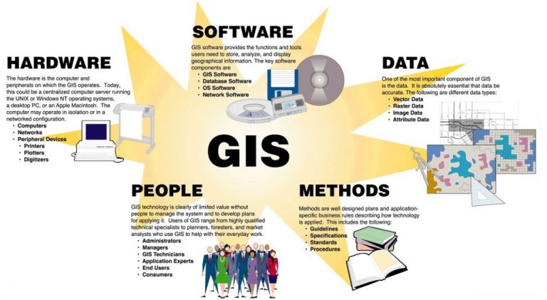
A Geo-Application Administrator manages and optimizes CAD and GIS applications (such as web GIS systems). You are responsible for the technical and functional management of these systems, translate user requirements into technical solutions, and monitor the availability and performance of geo-applications.
The Geo-Application Administrator ensures that geographic information systems operate reliably and efficiently. The proper functioning of these systems means that users have access to up-to-date and accurate geographic data, which is essential for decision-making, planning, and operations.
At Geo-ICT, the Geo-Application Administrator combines administrative tasks with geographic information technology: you will work with CAD and GIS systems and assist users in using these systems, as well as handle the technical maintenance and upgrades of these (geo)applications.
The following skills are important for the Geo-Application Administrator role:
A typical workday might look like this:
Yes, Geo-ICT offers programs that will train you for this role and may allow you to start working in this position right away. Check out the Geo-ICT Traineeship job posting and apply today!
In the role of Geo-Application Manager, you can advance to positions such as Senior Geo-ICT Application Manager, GIS Platform Manager, or Geo-Data & Application Development Specialist. Gaining additional expertise in cloud platforms, API integration, or geo-data workflows will enhance your career prospects.
Yes and No — traditional application management primarily requires technical IT skills, but with a focus on GEO, knowledge of geoinformation technology (such as GIS, GPS location analysis, and geodatabases) gives your role as a Geo-Application Manager an extra edge. This allows you to better integrate systems with geodata processes.
This role involves adhering to quality and management standards such as: proper version and configuration management of applications, monitoring availability, documenting changes, ensuring that users have access to the correct data and functionality, and ensuring that systems are secure and well-maintained.
You can apply directly for the Geo-ICT Traineeship or contact us via the widget on the page by entering your name, email address, and phone number to schedule a no-obligation conversation. You can also send us a WhatsApp message. If you have any questions about the program or whether the position is a good fit for you, please feel free to contact us.