Data Scientist Position

In the role of geospatial data scientist, one engages in the scientific analysis and interpretation of geographic data to gain insights and discover models. These models are applied in machine learning systems. This role requires knowledge and skills in geographic information systems (GIS), data analysis and visualization, statistics, and machine learning.

What a Data Scientist Does

Geo-ICT Training Center, Nederland - Functie Geospatial Data-Scientist

As a geospatial data scientist, you play a crucial role in handling and analyzing large amounts of data within an organization. Your ability to gain insights from this data is invaluable. You dive into big data to solve complex problems by developing algorithms that allow you to identify specific patterns and formulate recommendations that are critical to strategic decision-making within a company.

A typical day in the life of a Data Scientist might involve reviewing data analyses, prioritizing adjustments or optimizations, and collaborating with other specialists. You’ll be involved in developing and improving predictive models, cleaning and processing data, and communicating these insights to stakeholders. Some of the tools and technologies you might use on a daily basis include:

  • SQL for working with databases
  • Jupyter Notebook for sharing code and results
  • Tableau for data visualization
  • Hadoop and Apache Spark for processing large datasets
  • TensorFlow for building deep learning models
  • GitHub for version control and collaboration.

Some of the key responsibilities include:

  • Designing, managing, and optimizing data systems and databases
  • Solving business problems by analyzing and selecting the best statistical methodologies
  • Describing and visualizing the insights discovered and reporting them to management
  • Developing predictive models and identifying patterns
  • Combining different types of data and detecting anomalies within this data.

You must possess strong analytical skills, attention to detail, perseverance, and innovation. Knowledge of data science tools such as SQL, R, and Python is essential, as is the ability to accurately analyze, model, and interpret big data.

The role of a Data Scientist is both challenging and rewarding, with ample opportunities for career growth and specialization in fields such as artificial intelligence, machine learning, and data visualization. The average salary for a Data Scientist is around €3,900 per month, depending on experience and education, with opportunities for advancement to higher and more specialized roles.

In this role, you’ll be on the front lines of technological innovation and help shape the future of companies and organizations across a wide range of sectors.

Why is the work of a Data Scientist important?

In today’s data-driven world, the importance of Data Scientists cannot be overstated. Their work is crucial for both organizations and society at large, thanks to their ability to distill valuable insights from complex and voluminous datasets. This ability enables companies to make more informed decisions, minimize risks, and drive innovation. Here are some key aspects that highlight the importance of data scientists:

  • Insight into Customer Behavior: By thoroughly analyzing customer data, data scientists can identify patterns and trends that are essential for adapting and optimizing marketing efforts and product development.
  • Efficiency Improvements and Cost Savings: Data scientists help optimize business processes, which can lead to significant cost savings. For example, using data for predictive maintenance can reduce operational costs and increase equipment uptime.
  • Risk Management: By leveraging predictive analytics and AI technologies, data scientists can identify potential risks early on and propose measures to mitigate them. This prevents problems before they arise, a “prevention rather than cure” approach.
  • Innovation and Product Development: Data scientists play a key role in developing new products and services through their ability to create predictive models. This can lead to the launch of groundbreaking solutions that meet the evolving needs of consumers and businesses.
  • Data-Driven Decision-Making: The insights provided by data scientists support decision-making at all levels within an organization, from marketing to product development and risk management. This provides a strategic advantage in a competitive market.

The work of a data scientist is therefore not only important for the individual success of an organization but also plays a key role in promoting social progress and addressing complex challenges. By using data in an ethical and responsible manner, they can contribute to a better future for everyone.

The Impact of Geoinformation on a Data Scientist

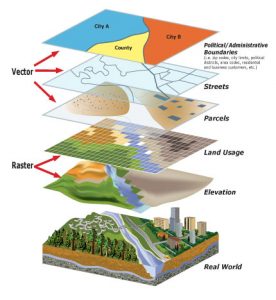
The role of geoinformation in the work of data scientists is significant and multifaceted, with a direct impact on decision-making, risk management, and planning across various sectors. Geo-information, characterized by the addition of location (X and Y coordinates) to data, plays a crucial role in the work of data scientists by enabling spatial analysis and the visualization of data on maps. This enables them to discover patterns, trends, and relationships that would remain hidden without the spatial component.

An important application of geoinformation within data science is Geographic Information Systems (GIS). GIS offers the ability to work with map layers, where specific data can be linked to each layer. This makes it possible to investigate and solve complex spatial problems. Examples of GIS applications range from planning emergency response during disasters and protecting vulnerable nature areas to analyzing the spread of diseases in relation to a region’s geographic characteristics.

The value of geoinformation extends further into the business sector and public order and safety, where organizations such as CityGIS and Cobra specialize in providing Geographic Coordination & Information Systems that are crucial for rapid and accurate decision-making.

The integration of geoinformation with other data sources enriches the analytical capabilities of data scientists, enabling them to:

  • Gain insights into customer behavior by linking demographic data to locations.
  • Increase efficiency by geographically optimizing business processes.
  • Manage risks by performing location-based analyses that identify potential hazards early on.

It is important to recognize that, while digital geoinformation offers many opportunities for zooming in and detailed analysis, the quality of this data is of critical importance. Accuracy, precision, reliability, and context of use are all factors that determine the quality of geoinformation and must be taken into account when using it in GIS applications.

In short, the impact of geoinformation on the work of a data scientist is significant and facilitates a deeper understanding of both the physical and social worlds by enabling advanced spatial analyses and visualizing complex data structures in a geographic context.

Inform & Apply

Choose fileNo file chosen
Max. file size: 200 MB.

Want to know more?

Do you have questions about the course content? Or are you unsure whether the course aligns with your learning goals or preferences? Would you prefer an in-house or private course? We’d be happy to help.

Education

A geospatial data scientist has a strong academic background, typically starting with a university-level degree in a scientific field. To tailor their knowledge and skills specifically to the unique demands of working with spatial data, further specialization is essential. Specialized courses such as the Data Analysis and GIS Course, R Programming, and Machine Learning Python are indispensable for this. These courses provide the theoretical knowledge and practical skills needed to perform complex data analysis and develop innovative solutions in the field of geoinformation.


The expertise of a geospatial data scientist is widely applicable and invaluable to a diverse range of clients. These include:


  • Municipalities and government agencies, where the analysis of spatial data is crucial for urban planning and policy-making.
  • The Land Registry, which relies on accurate geospatial analyses for managing real estate and land use.
  • Engineering firms, water boards, and provinces, where detailed geospatial data contributes to the design and management of infrastructure and environmental projects.
  • Contractors, who rely on precise geospatial information for the planning and execution of construction projects.


The unique combination of in-depth scientific knowledge with specialized technical skills makes the geospatial data scientist a key figure in the successful application of geoinformation across various sectors.

Tasks

A geospatial data scientist plays a crucial role in the world of geoinformation. Their responsibilities span a wide range of tasks, from collecting and analyzing data to developing models that form the basis for future predictions. Below is an overview of their core activities:


  • Data collection and analysis:
    • Collecting geographic data from various sources, including satellite imagery, maps, sensors, and other geographic databases.
    • Modeling this data to gain in-depth insights and understand how geographic patterns evolve.


  • Modeling and forecasting:
    • Developing models and algorithms essential for analyzing geospatial data.
    • Using these models to make accurate predictions about future events or trends.


  • Geospatial data visualization:
    • Visualizing geospatial data in a format that is easy to interpret and model.
    • Using advanced tools to make complex data clear and accessible.


  • Spatial data management:
    • Scientific management of geospatial datasets.
    • Continuously improving models used in machine learning to increase the accuracy and usability of data.


  • Collaboration and communication:
    • Working in multidisciplinary teams with professionals such as urban planners, environmental experts, policymakers, and engineers.
    • Effectively communicating and collaborating with various stakeholders to successfully complete projects.


The geospatial data scientist serves as the bridge between complex geospatial data and its practical applications in the real world. Their expertise enables the transformation of data into valuable insights, which is essential for planning and executing projects across various sectors.

Frequently Asked Questions About the Data Scientist Role

Een Data Scientist analyseert grote hoeveelheden gegevens, inclusief geografische data, om inzichten te verkrijgen, patronen te ontdekken en voorspellende modellen te ontwikkelen. Binnen Geo-ICT richt deze functie zich op geospatial data, self-learning machines en het toepassen van statistiek, machine learning en GIS-vaardigheden.

De functie Data Scientist is belangrijk omdat organisaties in een steeds meer datagedreven wereld afhankelijk zijn van betrouwbare inzichten en modellen om beslissingen te nemen, processen te optimaliseren en innovaties door te voeren.

Bij Geo-ICT ligt de nadruk op de combinatie van data science en geo-informatie: je werkt specifiek met locatiegegevens, kaartlagen, ruimtelijke analyses én machine-learning-modellen. Deze combinatie maakt de functie Data Scientist meer specialistisch met een geo-context.

Voor de functie Data Scientist zijn onder andere de volgende vaardigheden belangrijk:

  • Programmeertalen zoals Python, R en kennis van SQL.
  • Frameworks en tools voor machine learning en big data (bijv. TensorFlow, Spark, Hadoop).
  • Kennis van geo-informatiesystemen (GIS), ruimtelijke databanken en (GPS)-locatieanalyse.
  • Analytisch vermogen, statistische kennis en communicatieve vaardigheden om inzichten helder over te brengen.

Een typische werkdag kan er als volgt ongeveer uitzien:

  • Je begint met het verzamelen, opschonen en integreren van geospatial datasets.
  • Je bouwt of verbetert een machine-learning-model om patronen of trends in locatie- of sensor-data te ontdekken.
  • Je voert tests uit, valideert het model en bespreekt de bevindingen met stakeholders.
  • Je visualiseert de resultaten, bijvoorbeeld met kaarten of dashboards, en maakt deze bruikbaar voor besluitvorming.
  • Je plant de volgende iteratie, voert performance‐monitoring uit, en onderhoudt je dataarchitectuur.

Jazeker! Geo-ICT biedt trajecten waarin je opgeleid wordt voor deze functie en aan de slag kunt, bekijk daarvoor de Geo-ICT traineeship vacature en solliciteer direct!

Voor de functie Data Scientist kun je doorgroeien naar rollen zoals Lead Data Scientist, Data Architect of Specialist Geo-AI (artificial intelligence voor geo-data). Door extra ervaring met cloud-platformen, MLOps en geo-informatietechniek vergroot je je carrièrekansen.

Hoewel je als Data Scientist al veel bereikt met algemene data science-vaardigheden, geeft kennis van geo-informatietechniek (zoals GIS, locatieanalyse en geo-databases) je rol in de Geo-ICT extra kracht. Je kunt dan direct bijdragen aan geo-data gedreven projecten.

In de functie Data Scientist gelden kwaliteitsnormen zoals: correcte verwerking en documentatie van data, datagovernance (metadata, traceerbaarheid), betrouwbare en uitlegbare machine learning modellen, en betrouwbare visualisatie van inzichten. Ook ethisch verantwoord omgaan met data en privacy/veiligheid van locatiegegevens is van belang.

Je kunt direct solliciteren op het Geo-ICT Traineeship of via de pagina’s widget contact opnemen door je naam, e-mail en telefoon­nummer in te vullen voor een vrijblijvend gesprek. Ook kun je ons een WhatsApp-bericht sturen. Voor vragen over de inhoud of of de functie aansluit kun je eveneens contact opnemen.