
Collecting geospatial data at sea
Collecting geospatial data at sea
As a hydrographer, you play an essential role in the world of water and navigation. Your daily tasks range from measuring water depths to analyzing water composition. But what does a hydrographer actually do on a daily basis?
In addition to these technical aspects, geoinformation plays a key role in your work. By collecting and analyzing geographic data, you can create detailed hydrographic charts that are essential for various maritime and ecological projects. You often use specialized software such as GIS to visualize this data.
The role of a hydrographer is important not only because you contribute to safer waterways and maritime activities, but also because you help protect our aquatic ecosystems. Your work has a direct impact on both local and global water management projects, making you a key player in the sustainability of our planet.
The work of a hydrographer is invaluable to our society, especially in a water-rich country like the Netherlands. This profession is essential for various aspects of both the environment and the economy. Here are a few reasons why:
The integration of geoinformation makes it possible to visualize complex data in an accessible way, allowing for better-informed decisions that impact both local and global scales. Consider projects such as coastal defense, where your input as a hydrographer directly contributes to the future safety and sustainability of our living environment.
This combination of technical skills and societal importance makes the work of a hydrographer indispensable. Through your expertise, you help not only ensure safety but also manage our natural resources responsibly.
The role of geoinformation in the work of a hydrographer cannot be underestimated. This advanced data helps shape all aspects of hydrographic work, from research to project implementation. Here’s how geoinformation influences your work as a hydrographer:
Integrating this data into your daily work ensures that you can not only work more efficiently but also contribute to sustainable solutions. All of this makes geoinformation an indispensable tool in your role as a hydrographer, allowing you to maximize your contribution to both local and global water management projects. Your expertise in manipulating and interpreting this data makes you indispensable in the pursuit of safer and more sustainable management of our water-rich environment.

Do you have questions about the course content? Or are you unsure whether the course aligns with your learning goals or preferences? Would you prefer an in-house or private course? We’d be happy to help.
As a hydrographer, you will complete the internationally recognized CAT B Hydrography training program. At the Geo-ICT Training Center in the Netherlands, hydrography professionals are trained to work for leading organizations. After completing your training, you may find employment at various large offshore companies, dredging firms, engineering firms, and even institutions such as water utilities and Rijkswaterstaat. There are also opportunities with contractors, the navy, major oil companies such as Shell and NAM, offshore construction firms, water boards, and the Hydrographic Service.
These extensive opportunities underscore the importance and versatility of the hydrographer role, allowing you to play a key role in both national and international water projects. Your expertise in hydrography makes you a valuable asset to each of these sectors, where you contribute to essential water management and protection.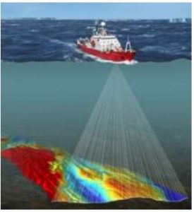
As a hydrographer, you are an expert in hydrography, specializing in measuring and mapping land and water surfaces. Below is an overview of your main responsibilities:
These tasks highlight your crucial role in ensuring the safety and accuracy of maritime and hydrographic projects.
A hydrographer is responsible for conducting hydrographic surveys of riverbeds and bodies of water, analyzing this data, and creating maps and models that depict underwater topography, depths, bottom structures, and other relevant features.
This role is essential because accurate hydrographic data ensures safe navigation for ships, reliable construction of offshore or coastal infrastructure, protection of aquatic ecosystems, and provides a basis for decision-making in water management.
At Geo-ICT, the profession of hydrographer is combined with geoinformation techniques: you work with hydrographic survey equipment as well as geodata and mapping materials, process data in GIS environments, and provide insights that are grounded in both technical and spatial considerations.
Key skills include:
A typical workday might look like this:
Often also consulting with colleagues or stakeholders regarding findings or follow-up actions.
Yes, Geo-ICT offers programs that train you for this role and may lead to a job opportunity. Check out our Geo-ICT Traineeship and apply now!
You can advance to roles such as Senior Hydrographer, Hydrographic Project Manager, or Marine Geo-Data & Underwater Surveying Specialist. By gaining additional knowledge of advanced surveying methods, geoinformation technology, or offshore applications, you can enhance your career prospects.
Although a Hydrographer’s core responsibilities involve surveying and fieldwork, knowledge of geoinformation (such as GIS, geodatabases, and cartographic materials) clearly adds value to this role. This enables you to process, analyze, and integrate survey data into spatial systems more effectively.
This position requires adherence to quality standards such as: proper calibration and maintenance of measuring equipment, accurate recording of measurement data and metadata, reliable processing into maps/models, and compliance with safety regulations for fieldwork (e.g., on the water) and equipment use.
You can apply directly for our Geo-ICT Traineeship or contact us via the widget on the page by entering your name, email address, and phone number to schedule a no-obligation conversation. You can also send us a WhatsApp message. If you have any questions about the program or whether the position is a good fit for you, please feel free to contact us.