Geo-ICT Training Center, Netherlands - Internet of Things Courses

Vrije Universiteit - UniGIS - MSc Geo-ICT Track

Geo-ICT Training Center, Netherlands, serves on the advisory committee for the UniGIS program. Individuals with a bachelor’s degree in a relevant field are eligible to enroll directly to this almost completely online, part-time MSc program. 

UniGIS is recognized worldwide and offers a Master of Science (MSc) in Geographical Information Sciences. It is a global network of universities that have been collaborating since 1990 to design and offer distance learning programs in geographic information systems and science.

Pre-Master

Individuals with a bachelor’s degree from a university of applied sciences can complete a pre-master’s program at Geo-ICT Training Center.

Would a part-time MSc in Geo-ICT be a good fit for me?

An increasing number of graduates from two-year and four-year higher education programs in fields such as:

Geography, Earth Sciences, Archaeology, Business Administration, Bioinformatics, Biology, Soil Science, Forestry and Nature Conservation, Chemistry, Cultural Heritage, Data Science, Defense, Animal Management, Ecology, Environment, Geodesy, Geomedia, History, Computer Science, International Business, Coastal and Marine Sciences, Agriculture, Surveying, Environmental Management, Environmental Science, Music Technology, Physics, Plant Sciences, Law, Spatial Development, Tourism, Water Management, Wildlife Management, Mathematics, Maritime Studies

deal with geoinformation in their work. An MSc in GIS offers many career opportunities. However:

Pursuing a part-time MSc program while working is quite demanding. The minimum study load is 16 hours per week. Most students take at least 3 years to complete the program.

Combining this program with a traineeship at our organization may also be a possibility.

Geo-ICT and GeoAI are used across all sectors.

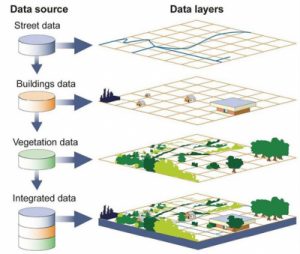
Developments in geospatial information and communication technology (Geo-ICT) and GeoAI are advancing at a rapid pace.  The emergence of geospatial data, satellite navigation, and geographic information systems (GIS) has accelerated the possibilities for geographic data acquisition, analysis, and visualization. This is leading to various new applications in different fields, such as spatial planning, environmental management, transportation, agriculture, and smart cities.

Profile photo of Suzy Palmer-Smith. Our International Education Coordinator

My name is Suzy Palmer-Smith. Course Coordinator. Would you like more information?

Contact

Frequently Asked Questions

The UNIGIS program is an internationally recognized educational network in the field of GIS and Geo-ICT. As part of the MSc Geo-ICT program, you will collaborate with UNIGIS through VU University Amsterdam, allowing you to benefit from high-quality academic education combined with international expertise and practical applications.

Yes, the program is designed to be flexible and can easily be combined with work or an internship. Many participants take the course while working or combine it with an internship through the Geo-ICT Training Center, where theory and practice come together directly.

The MSc Geo-ICT is designed for professionals and graduates with a background in fields such as geography, geodesy, ICT, or data analysis. Candidates who wish to transition into GIS, GeoAI, or spatial data analysis are also welcome.

Upon graduation, you can pursue a career as a GIS specialist, geodata analyst, GeoAI engineer, or consultant within government agencies, engineering firms, and international organizations. Thanks to the combination of academic knowledge and practical experience, graduates are highly sought after in the job market.