During your studies, you’ve already been introduced to one or more aspects of Geo-ICT. This gives you a solid foundation as a junior Geo-ICT professional. But where exactly do you stand, and what knowledge do you still need to further your development?
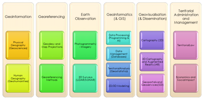
In this course, we’ll use the six fundamentals of Geo-ICT as a framework: Geo-information, Georeferencing, Earth Observation, Geoinformatics, Geo-visualization, and Land Management. You’ll discover what knowledge you already have, how the various components of Geo-ICT are interconnected, and in which areas you can further develop your skills.
Based on this, you’ll gain insight into which courses and specializations best align with your background and future career in Geo-ICT.
Course duration: 3 days
Taught by:
Dutch
Introduction to Geo-ICT with the Geo-ICT Basics Course
Geo-ICT stands for Geographic Information and Communication Technology and brings together location, spatial data, and ICT. In our society, more and more information is linked to a specific location. Roads, buildings, water, soil, nature, energy infrastructure, and virtually all other components of our physical environment can be recorded, managed, and analyzed as geographic information.
Within Geo-ICT, data about the physical environment is collected, georeferenced, managed, analyzed, visualized, and applied. A wide range of techniques and technologies are used for this purpose, such as GIS, satellite data, drones, GNSS, sensors, spatial databases, ETL, and web technology.
The Geo-ICT Basics course provides you with a broad introduction to this field. You will not only learn how to work with geographic data, but more importantly, how to understand where this data comes from, how location is determined, how geo-data is processed, and how geographic information is ultimately used to solve spatial problems.
What Is Geo-ICT? From the Physical World to Geographic Information
Geo-ICT forms the digital link between the physical world and the information we use to understand, manage, and change that world. Real-world objects and phenomena are recorded as geo-data and linked to a location.
During the course, you’ll be introduced to different types of geo-data and learn, among other things, the difference between vector and raster data. Topics such as attributes, map layers, coordinates, metadata, and data quality will also be covered.
You’ll discover that Geo-ICT is much broader than just GIS or mapmaking. The field encompasses the entire chain, from data collection to the use of geographic information for analysis and decision-making.
The Six Foundations of Geo-ICT
To bring coherence to the broad field of Geo-ICT, we build on six foundations throughout the course. Together, these form the basis for the work of a Geo-ICT professional:
Geo-information: understanding geographic information, geo-data, objects, attributes, data models, quality, and metadata.
Georeferencing: linking information to a location using coordinates, reference systems, GNSS, and surveying techniques.
Earth Observation: observing and collecting information about the Earth using, among other things, satellites, drones, LiDAR, and sensors.
Geoinformatics: managing, processing, and analyzing geographic information using GIS, databases, ETL, programming, and other ICT technologies.
Geo-visualization: presenting geographic information in an understandable way using maps, webGIS, dashboards, and 3D visualizations.
Land Management: the application of geographic information in the planning, use, and management of the physical environment.
The six foundations are not treated as separate disciplines. Rather, the focus is on their interconnections. For example, a satellite image must be acquired and correctly georeferenced before it can be processed, analyzed, visualized, and applied to a spatial issue.
Geo-ICT in Practice: From Data Acquisition to Application
Geo-data can be acquired in many different ways. Examples include land surveying, GNSS, satellites, drones, laser scanning, and sensors. During the course, you’ll learn the basics of how these techniques contribute to gathering information about our environment.
This data must then be stored, verified, combined, and processed. You will therefore be introduced to GIS, spatial databases, and ETL. ETL stands for Extract, Transform, Load, and is used to retrieve data from various sources, transform it, and transfer it to other systems or data formats.
Topics such as SQL, FME, web services, APIs, Python, and automation are also covered in general terms within the Geo-ICT landscape. The goal here is not to master all these technologies completely right away, but to understand the roles they play and how they relate to one another.
What You’ll Learn in the Geo-ICT Basics Course
Fundamentals of Geo-ICT: From Geo-Data to GIS
During the course, you’ll build a broad foundation of knowledge regarding the most important concepts and techniques in Geo-ICT. Among other things, you’ll learn:
Understanding Geo-Data: working with geographic objects, attributes, vector, and raster data.
Understanding location: getting familiar with coordinates, reference systems, and georeferencing.
Recognizing data collection: understanding how GNSS, surveying, satellites, drones, and sensors collect geo-data.
Using GIS: viewing, combining, managing, analyzing, and visualizing geographic data.
Processing geodata: an introduction to databases, SQL, ETL, FME, web services, and APIs.
Presenting Geo-Information: Understanding how maps, WebGIS, dashboards, and 3D visualizations make information accessible.
By connecting these components, you’ll gain insight into the entire Geo-ICT chain and learn to recognize where different techniques and applications fit within the field.
Practical Skills: Working with Geo-Data and Geo-ICT
During the course, you’ll also gain hands-on experience with geographic data. We’ll use tools such as QGIS to view, combine, analyze, and visualize various types of geo-data.
The practical exercises reinforce the theory. For example, you’ll learn how different datasets can be combined, why a correct coordinate system is important, and how usable geographic information is derived from raw geodata.
The focus is not on any single software package. The goal is for you to understand the underlying Geo-ICT principles, so that you can more easily transition to different software packages, techniques, and specializations later on.
Applications of Geo-ICT: From Water Management to the Energy Transition
Geo-ICT is used in virtually every field where location and the physical environment play a role. During the course, we’ll examine examples from areas such as water management, infrastructure, energy, nature, land-use planning, geodesy, hydrography, remote sensing, and public space management.
This approach teaches you not only which techniques are available, but above all why and when they are applied. The six fundamentals consistently serve as the common thread linking the technology to the ultimate spatial challenge.
Why Choose Our Geo-ICT Basics Course?
The Geo-ICT Basics Course is designed for anyone who wants to build a broad and coherent foundation in Geo-ICT. Instead of focusing immediately on a single software package or specialty, you’ll first learn to understand how the entire field of Geo-ICT is structured.
Broad Foundation: You’ll be introduced to the most important concepts, techniques, and applications within Geo-ICT.
Six Foundations: Geo-information, Georeferencing, Earth Observation, Geoinformatics, Geo-visualization, and Land Management form the core thematic thread.
Practical Learning: Theory is linked to practical exercises using real geodata.
Understanding the Big Picture: You’ll learn how the collection, positioning, management, analysis, visualization, and application of geodata are interconnected.
Foundation for Further Study: After the course, you’ll be able to pursue more focused learning in various Geo-ICT techniques and specializations.
After completing this course, you’ll have a broad understanding of the Geo-ICT field and will understand how the various components within the Geo-ICT chain are interconnected. This will provide you with a solid foundation for your continued development as a Geo-ICT professional.
Recognize and use different types of geographic data, including vector, raster, and attribute data.
Open, view, combine, and verify geographic data in a GIS environment such as QGIS.
Work with coordinates and coordinate reference systems, and recognize when datasets do not align correctly.
Explain how geospatial data is collected using methods such as GNSS, land surveying, satellites, drones, and sensors.
Perform simple spatial analyses and select, filter, and combine data to answer a practical question.
Explain how geospatial data is stored and exchanged via files, spatial databases, web services, and APIs.
Recognize a simple ETL process and understand how geodata can be imported, transformed, and exported using tools such as FME.
Clearly present geo-information on a map and determine what information is needed for a specific user or application.
Recognize the six fundamentals—Geo-information, Georeferencing, Earth Observation, Geoinformatics, Geo-visualization, and Land Management—and relate them to practical Geo-ICT tasks.
Walk through a simple Geo-ICT chain: from acquiring and positioning geodata to managing, analyzing, visualizing, and applying it.
Want to know more?
Do you have questions about the course content? Or are you unsure whether the course aligns with your learning goals or preferences? Would you prefer an in-house or private course? We’d be happy to help.
Geo-ICT is the field where geographic information and ICT converge. Internationally, terms such as Geoinformatics, Geo-information Science, GIScience, and Geomatics are often used to describe this field. The field extends far beyond GIS and mapmaking. It encompasses the entire process, from the collection and positioning of geodata to its management, analysis, visualization, and application. Technologies such as GIS, GNSS, remote sensing, databases, ETL, programming, WebGIS, and GeoAI are all part of this field.
Geo-ICT is offered at universities under various names. In the Netherlands, for example, you can study Geo-Information Science at Wageningen University & Research and Geo-Information Science and Earth Observation at the ITC of the University of Twente. TU Delft approaches the field through Geomatics. Internationally, there are many comparable degree programs in the fields of Geoinformatics, Geomatics, and GIScience. While the names of the programs may differ, a large portion of the underlying subject matter is the same.
Not every university uses the six foundations—Geo-information, Georeferencing, Earth Observation, Geoinformatics, Geo-visualization, and Land Management—in exactly those terms. However, these various fields of study are clearly recognizable in the curricula. Depending on your program of study, for example, you may have already worked with GIS, remote sensing, surveying, GNSS, databases, programming, cartography, or spatial issues. During the Geo-ICT Basics course, we use the six foundations to organize this knowledge. This gives you insight into what you’ve already mastered, where you stand as a junior Geo-ICT professional, and in which areas further study or a supplementary course would be beneficial.
Geodesy is an important part of the broader field of Geo-ICT, but Geo-ICT encompasses more than that. Geodesy focuses, among other things, on the accurate measurement and determination of positions, distances, elevations, coordinates, and the shape of the Earth. Within the six pillars, this is particularly reflected in georeferencing. Geo-ICT also encompasses, for example, Earth Observation, GIS, databases, data processing, visualization, and the application of geoinformation. A geodesist can therefore be a Geo-ICT professional, but a Geo-ICT professional does not necessarily have to be a geodesist.
Request a quote
Search the website
Find courses, MOOC content, articles and more in one place.