Basics of Hydrography

ZD - Hydrography

In this three-day course, you’ll learn the basics of hydrography and discover how water depths and riverbeds are measured and mapped. You’ll learn about positioning, sonar, water levels, and hydrographic data processing, and you’ll head out onto the water yourself to take measurements. A practical first step for anyone who wants to get acquainted with the field of hydrography.

Course duration: 3 days
3.8
8

Introduction to Hydrography

Geo-ICT Training Center, Nederland - Cursus Hydrografie Basis

Hydrography focuses on measuring and mapping water bodies and the seabed. Hydrographic data is used for applications such as shipping, dredging, water management, coastal management, and offshore projects. This field brings together geodesy, positioning, depth measurement, and Geo-ICT.

In the Basic Hydrography Course, you’ll be introduced to the key principles of hydrographic surveying. You’ll learn how to use GNSS to determine the position of a measurement and how to measure water depths using echo sounders and sonar. We also cover water levels, vertical reference levels, and the corrections needed to obtain reliable depth data.

A hydrographic survey ultimately yields geographic data. That is why you will also learn how survey data is verified, processed, and visualized. Using QGIS, you will work with hydrographic data to create, among other things, longitudinal profiles, cross-sections, and an image of the underwater seabed.

The course combines theory and data processing with hands-on practice. On the third day of the course, you’ll take a boat out onto the Apeldoorns Canal. You’ll conduct a simple hydrographic survey yourself, measuring a longitudinal profile and various cross-sections of the canal. The collected data is then processed and analyzed in QGIS.

The Basic Hydrography Course thus offers a broad and practical introduction to hydrography and provides a solid foundation for further study in areas such as bathymetry, hydrographic data processing, multibeam, and sonar data.

The Importance of Hydrography

A large part of our environment consists of water. To navigate safely, maintain waterways, carry out dredging operations, or construct structures on and around the water, we need to know what the underwater bottom looks like. Hydrographic surveys provide the necessary information for this.

Hydrography is applied at sea, as well as on rivers, canals, lakes, and in harbors. Its applications range from creating and updating nautical charts to monitoring navigation channels and identifying changes in the seabed.

  • Shipping: determining available water depth and safe navigable routes.
  • Water management: mapping and monitoring the bottoms of rivers, canals, and other waterways.
  • Dredging operations: determining where sediment needs to be removed and verifying the results.
  • Offshore: supporting operations related to, for example, wind farms, cables, and pipelines.
  • Coastal and river management: monitoring changes in the riverbed and banks.

Hydrography is thus a field par excellence where surveying, geodesy, and Geo-ICT converge.

From Position and Depth Measurement to Geodata

A measured water depth is only useful if it is also known where this depth was measured and relative to which reference level. Positioning and geodesy are therefore an important part of hydrography.

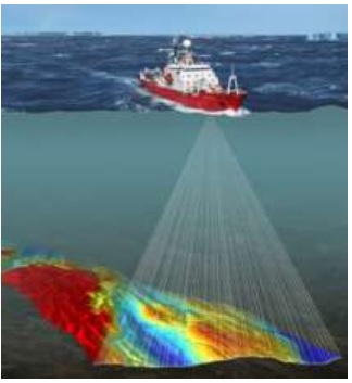
During the course, you will learn how GNSS is used to determine the position of the survey vessel. We will also cover how an echo sounder or sonar uses sound waves to measure the distance to the water bottom and which factors influence the accuracy of a depth measurement.

Water levels and vertical reference levels are also important. The measured depth must be linked to a usable reference level so that measurements from different locations and times can be compared with one another.

What will you learn in the Basic Hydrography Course?

Understanding Hydrographic Surveys

You’ll learn, step by step, how a simple hydrographic survey is structured. We’ll examine the relationship between position, water depth, water level, and reference level. You’ll be introduced to echo sounders and sonar, as well as the difference between single-beam and multibeam measurements.

We’ll also focus on the quality of hydrographic measurement data. You’ll learn why measurement data must be verified and which conditions and corrections can affect the final result.

Processing Hydrographic Data with QGIS

Hydrographic surveys yield large amounts of spatial data. During the course, you’ll learn how to view, verify, and visualize this data in QGIS.

You’ll work with survey points and depth data and learn how to create longitudinal and cross-sectional profiles from them. This process transforms individual measurements into a geographic representation of the shape and depth of the waterbed.

Field Survey on the Apeldoorns Canal

On the third day of the course, we’ll put theory into practice. We’ll take a boat out onto the Apeldoorns Canal and conduct hydrographic surveys ourselves.

During this hands-on day, we’ll measure a longitudinal profile of a section of the canal and take cross-sectional measurements at various locations. This will give you firsthand experience of how positioning, depth measurement, navigation lines, and measurement setups come together in practice.

The collected measurement data is then processed and visualized, allowing you to walk through the entire processβ€”from measuring on the water to generating usable Geo-ICT information.

Why choose our Basic Hydrography Course?

The Basic Hydrography Course combines the fundamentals of hydrography with practical Geo-ICT skills and hands-on fieldwork.

  • Broad foundation in hydrography: you’ll learn the key principles of positioning, depth measurement, water levels, and hydrographic data processing.
  • Working with QGIS: You’ll learn to process, analyze, and visualize hydrographic survey data.
  • Conducting your own measurements on the water: During the field day, you’ll conduct a simple hydrographic survey yourself on the Apeldoorns Canal.
  • The complete measurement chain: You’ll experience the entire process, from preparation and data collection to processing and presentation of the measurement data.
  • Foundation for further specialization: The course provides a solid foundation for specialized topics such as bathymetry, hydrographic data processing, multibeam, and sonar data.

By the end of the course, you’ll understand how a hydrographic survey is planned and carried out, and how the collected data is processed into usable geographic information.

Read more

Enroll

€1695,-
  • Workload: 3 Course days from 9:00 AM to 4:00 PM
  • Location: Apeldoorn or Online. On-site is also possible. Please get in touch for a quotation.
  • Date: Multiple start dates are available; please see the registration page.
Register for this course

Daily Schedule

Day 1 – Fundamentals of Hydrography and Hydrographic Surveying

On the first day, you’ll be introduced to the field of hydrography and its main applications at sea and on inland waterways. We’ll cover the basics of hydrographic surveying and examine the relationship between position, water depth, and reference level.

You’ll learn how GNSS is used for positioning and become familiar with coordinate and reference systems. We’ll also cover water levels, vertical reference levels, and their impact on depth measurements. This will give you insight into the various components required to perform a reliable hydrographic survey.

Day 2 – Depth Measurement, Sonar, and Hydrographic Data Processing

On the second day, the focus is on measuring the lake bottom. You’ll learn how echo sounders and sonar work and be introduced to single-beam and multibeam measurements. We’ll cover topics such as the speed of sound, accuracy, and corrections that affect the measured water depth.

Next, you’ll work with hydrographic survey data in QGIS. You’ll learn how to view, verify, and visualize survey points and depth data, and you’ll be introduced to longitudinal and cross-sectional profiles. We’ll also prepare for the field survey on the third day and determine how we’ll measure the longitudinal and cross-sectional profiles.

Β 

Day 3 – Field Measurement on the Apeldoorn Canal

On the third day, we’ll put theory into practice. We’ll take a boat out onto the Apeldoorns Canal and conduct a simple hydrographic survey ourselves. We’ll measure a longitudinal profile of a section of the canal and several cross-sections at various locations.

While sailing, you’ll experience how positioning, depth measurement, navigation lines, and survey setup all come together in practice. After the survey, we’ll process and visualize the collected data in QGIS. This will take you through the entire process, from conducting a hydrographic survey to creating usable geographic information.

Course duration: 3 dagen
Sign me up

Learning Objectives

  • Explain the main principles and applications of hydrography;
  • Explain how GNSS, coordinates, and reference systems are used in hydrographic surveys;
  • Describe the relationship between water depth, water level, and vertical datum;
  • Explain how echo sounders and sonar are used to measure water depths and the seabed;
  • Explain the difference between single-beam and multibeam measurements;
  • Identify key factors that influence the accuracy and quality of hydrographic surveys;
  • Prepare and conduct a simple hydrographic survey;
  • Measure a longitudinal profile and cross-sections of a waterway;
  • Process, verify, and visualize hydrographic measurement data in QGIS;
  • Understand the entire hydrographic survey chain: from positioning and depth measurement to processing and presenting the survey data.

Trainers

Ebelien van der Velde

Ebelien van der Velde

5.0
1 review
2 students went before you
E

Ebelien van der Velde

...
5.0
1 review
1 student went before you

Anoniem

2 years ago

Anoniem

2 years ago

Anoniem

4 years ago

Anoniem

4 years ago
View all reviews

Want to know more?

Do you have questions about the course content? Or are you unsure whether the course aligns with your learning goals or preferences? Would you prefer an in-house or private course? We’d be happy to help.

Frequently Asked Questions About Introduction to Hydrography

You will learn the key principles of hydrography and become familiar with positioning, GNSS, depth measurement, sonar, water levels, and reference levels. You will also learn how to process and visualize hydrographic survey data in QGIS and conduct a simple hydrographic survey yourself.

On the third day of the course, we’ll take a boat out onto the Apeldoorns Canal. We’ll sail along a route where we’ll measure a longitudinal profile and cross-sections at various points. We’ll also record our position and the water depth. Afterward, we’ll process and visualize the collected measurement data in QGIS.

A longitudinal profile follows the waterway in the longitudinal direction and shows how the bottom depth changes along its length. A cross-section runs from one side of the waterway to the other and provides insight into the shape and depth of the bottom across the width of the channel.

GNSS is used to determine where a measurement was taken. An echo sounder or sonar is used to determine the distance to the lake bottom. By combining position and depth measurements, measurement points can be georeferenced and the shape of the lake bottom can be mapped.

Yes. Hydrography Basics provides you with a broad foundation and insight into the entire measurement chain. After that, you can use Blended Learning to delve deeper into specialized topics such as bathymetry, hydrographic data processing, multibeam, and sonar data.

The course is highly relevant, as it provides insights into coastal management and safe navigation, which are essential for maritime transport and offshore operations.

Yes, an important part of the course is learning how to process hydrographic data, including plotting depth contours.

You will learn about coordinate systems, scales, symbols, map projections, and identifying underwater hazardsβ€”all of which are essential for producing accurate hydrographic charts.

Yes, after completing this course, you can continue with the certified CAT B Hydrography program to further your specialization.