• Searching...

Result 49 - 60 of 87 courses

Python QGIS

Python
  • Certified
  • Workload: 24 hour

Python TKinter

  • Workload: 24 hour

QField for Mobile Data Collection

QGIS
  • Certified
  • Workload: 24 hour

QGIS 3D Visualization

QGIS
  • Certified
  • Workload: 24 hour

QGIS Advanced

QGIS
  • Certified
  • Workload: 24 hour

QGIS Basics

QGIS
  • Certified
  • Workload: 24 hour

QGIS Cartography

QGIS
  • Certified
  • Workload: 24 hour

QGIS ChatGPT

QGIS
  • Certified
  • Workload: 24 hour

QGIS Choropleths

QGIS
  • Certified
  • Workload: 24 hour

QGIS Climate Adaptation

QGIS
  • Certified
  • Workload: 24 hour

QGIS Copernicus

QGIS
  • Certified
  • Workload: 24 hour

QGIS Environment

QGIS
  • Certified
  • Workload: 24 hour

Why choose a course at Geo-ICT Training Center, The Netherlands?

55

Courses

82

Blended Learnings

1200

Participants per year

What is Blended Learning?

Blended Learning is an educational approach that combines live, face-to-face online instruction with digital learning experiences. This approach integrates the strengths of both live virtual and self-paced digital environments to create a flexible, personalized learning experience for students.

Key components of Blended Learning include:

  1. Face-to-face instruction: Traditional teaching methods like lectures, discussions, and in-class activities.
  2. Online learning: Digital content delivered through video lessons, interactive modules, and online discussions.
  3. Student control: Learners have the flexibility to control the time, pace, path, or place of their learning through online components.

Blended learning is increasingly popular as it leverages technology to provide more individualized instruction, support diverse learning styles, and combine synchronous (real-time) with asynchronous (self-paced) experiences.
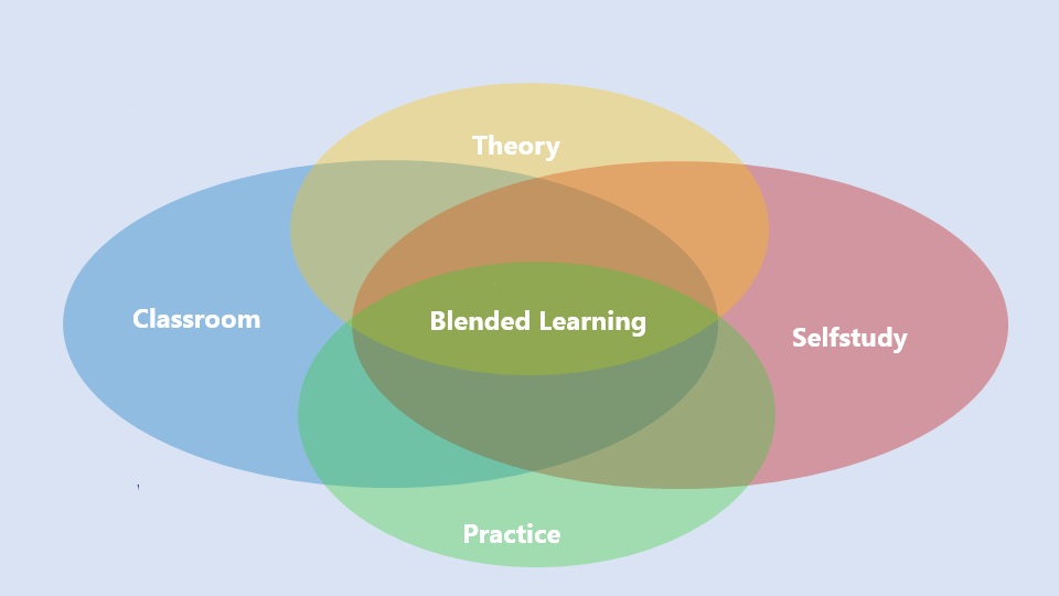
A Venn diagram with four overlapping ovals labeled "Classroom" (blue, left), "Selfstudy" (red, right), "Theory" (yellow, top), and "Practice" (green, bottom). At the center, where all four areas overlap, is "Blended Learning" shown in green. The image illustrates that blended learning is a combination of theory, practice, classroom instruction, and self-study.

In the QGIS and Python course you will learn GIS programming, creating plugins, developing tools, and applying programming concepts such as control-flow statements and data structures in QGIS and Python.

This course is ideal for starting geo specialists, experienced geo professionals, reskillers, and employees of companies in the geo sector who want to develop their skills in QGIS and Python.

The QGIS And Python course is a 3-day training in which you work intensively on improving your GIS and Python skills.

Python provides powerful capabilities for automation, developing custom tools and functions, and efficiently processing geospatial data in QGIS.

Yes, the course includes practical exercises where you will learn how to write and deploy Python scripts within QGIS, and how to develop your own plugins and tools.

The course focuses on understanding QGIS and Python interoperability, data management and analysis, automating tasks in QGIS with Python, and developing QGIS plugins with Python.

You will learn to write Python scripts for QGIS, manage and analyze geographic data, automate tasks and develop QGIS plugins.

Yes, after the course you can still ask questions to the teacher via email for two weeks, and there is also the option for Online Support for practical problems.

The course days are from 9:00 AM to 4:00 PM, including coffee, tea, lunch and a laptop. Online participation is also possible.

Yes, the course can be given on location. The teacher will bring laptops and you only have to arrange a classroom.