• Searching...

Result 13 - 24 of 88 courses

Geonode Basics

WebGIS
  • Certified
  • Workload: 24 hour

Geonode Configuration

WebGIS
  • Certified
  • Workload: 24 hour

Google Earth Engine Applications

Google Earth
  • Certified
  • Workload: 24 hour

Google Earth Engine Basics

Google Earth
  • Certified
  • Workload: 25 hour

Google Earth Engine ChatGPT

Google Earth
  • Certified
  • Workload: 24 hour

Google Earth Engine Earth Observation

Google Earth
  • Certified
  • Workload: 24 hour

Google Earth Engine for Agrohydrological Applications

Google Earth
  • Certified
  • Workload: 24 hour

Google Earth Engine for Spatial Data

Google Earth
  • Certified
  • Workload: 24 hour

Google Earth Engine QGIS

Google Earth
  • Certified
  • Workload: 24 hour

Google Earth Engine SDG

Google Earth
  • Certified
  • Workload: 24 hour

Hydrography Basics

Geodesy
  • Certified
  • Workload: 24 hour

Internet Mapping with Geoserver

WebGIS
  • Certified
  • Workload: 24 hour

Why choose a course at Geo-ICT Training Center, The Netherlands?

55

Courses

82

Blended Learnings

1200

Participants per year

What is Blended Learning?

Blended Learning is an educational approach that combines live, face-to-face online instruction with digital learning experiences. This approach integrates the strengths of both live virtual and self-paced digital environments to create a flexible, personalized learning experience for students.

Key components of Blended Learning include:

  1. Face-to-face instruction: Traditional teaching methods like lectures, discussions, and in-class activities.
  2. Online learning: Digital content delivered through video lessons, interactive modules, and online discussions.
  3. Student control: Learners have the flexibility to control the time, pace, path, or place of their learning through online components.

Blended learning is increasingly popular as it leverages technology to provide more individualized instruction, support diverse learning styles, and combine synchronous (real-time) with asynchronous (self-paced) experiences.
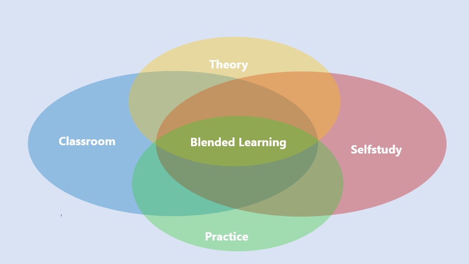
A Venn diagram with four overlapping ovals labeled "Classroom" (blue, left), "Selfstudy" (red, right), "Theory" (yellow, top), and "Practice" (green, bottom). At the center, where all four areas overlap, is "Blended Learning" shown in green. The image illustrates that blended learning is a combination of theory, practice, classroom instruction, and self-study.

FAQ Geonode Basics

No, you don’t need any programming experience. The course is designed for beginners and focuses on practical use of GeoNode. If you already have experience with tools like QGIS, you’ll gain deeper insights into data publishing and geoportal management.

By the end of the course, you’ll be able to manage the GeoNode interface, upload and publish datasets, configure user roles and permissions, and create a simple geoportal or spatial data infrastructure (SDI) for your own professional context.

This course is designed for professionals, students, and organizations working with geospatial data. It’s especially useful for GIS specialists, urban planners, researchers, policymakers, and anyone looking to share and manage geographic information in a professional environment.

The course is based entirely on open-source software. You’ll work with GeoNode as the main platform, and learn how it integrates with tools such as GeoServer and QGIS to build a robust geospatial data infrastructure.