Geo-ICT Training Center, International

Johan Cruijff Boulevard 83
1101 DM Amsterdam
www.geo-ict.com

Lead by

Geo-ICT Training Center, International - Hans van der Kwast

Associate Professor Hans van der Kwast

Hans brings over 20 years of expertise as a physical geographer, specializing in GIS and Remote Sensing. He currently serves as an Associate Professor of Open Science and Digital Innovation at IHE Delft Institute for Water Education. In addition to his academic role, Hans provides global consultancy, training, and coaching in open-source GIS, helping the geospatial sector advance to the next level.

Contact

Click here if you have a question. You can reach us by phone, WhatsApp, or email, and we aim to reply within one business day.

Free and opensource software

We believe the world belongs to everyone. GIS and geo-information should be accessible and affordable for all. That’s why we work exclusively with free and open-source software.

Lesson format

Our lessons take place through individual online sessions with a specialist. Artificial Intelligence is used to create customized learning materials that match your goals and experience level.

Entry Level

All participants hold at least a BSc, MSc, or PhD degree, ensuring a professional and advanced learning environment.


Our Vision: Uniting for a Sustainable Future

Geo-ICT Training Center, Netherlands - Vision

Humanity faces significant challenges as the Earth undergoes rapid and transformative changes. A strong geodetic supply chain and geo-information system is essential to achieving the UN’s Sustainable Development Goals by 2030. Around the world, there’s an increasing demand for skilled professionals who can collect, process, analyze, and interpret geo-information.

To meet this growing need, thousands of new professionals will be required in the geo-sector. These individuals deserve access to high-quality training and a solid foundation to kickstart their careers with the best resources and education available.

By harnessing the power of GeoAI, we can unlock potential far beyond what we once thought possible, driving innovation and accelerating progress toward a more sustainable world. We are committed to empowering individuals with the skills they need to succeed in this evolving field and make a meaningful impact on the future.

Our Mission: Learn by Doing – Master the Skills You Need Immediately

Geo-ICT Training Center, Nederland - Over ons

At Geo-ICT Training Center, we specialize in delivering hands-on training in the dynamic field of geodesy, which focuses on measuring the size, extent, orbit, and orientation of the Earth, as well as its gravitational field and sea level. This field is gaining renewed global attention, and we are committed to staying at the forefront by publishing, communicating, and sharing knowledge about it.

We offer a wide range of surveying and Geo-ICT courses every month, ensuring that our training reflects the latest technological advancements in areas like 3D CAD, 3D GIS, the Internet of Things, continuous sensors, drones, data analysis, and 3D scanning. We are dedicated to continuously updating and improving our course catalog, which currently includes over 200 practical, results-driven courses that are immediately applicable in real-world scenarios.

In addition, we offer advanced education in GeoAI, providing specialized learning opportunities to help you stay ahead in this evolving field.

Hi, I'm Suzy Palmer-Smith, Course Coordinator. Interested in learning more?

Click here

Frequently Asked Questions

Geo-ICT International is the global branch of the Geo-ICT Training Center in the Netherlands. It focuses on providing blended learning programs that combine online study with live instructor sessions. Through these programs, participants gain both theoretical and practical Geo-ICT skills. The initiative connects international students and professionals with real-world Geo-ICT projects. Graduates are trained and then placed in GIS positions worldwide. This approach helps organizations find qualified specialists in GIS, GeoAI and spatial data. Training topics include GeoAI, remote sensing, drones, and spatial databases. The blended learning model ensures flexibility for global learners across time zones. Trainees receive guidance from experienced Dutch geo-professionals. Overall, Geo-ICT International bridges global education and employment in the spatial industry.

Both ArcGIS and QGIS are powerful Geographic Information System (GIS) platforms, but they differ in licensing, flexibility, and typical use cases.

  • ArcGIS, developed by Esri, is a commercial platform widely used in professional and enterprise environments. It offers an extensive suite of tools for data analysis, management, and map visualization. Known for its user-friendly interface and robust technical support, ArcGIS requires a paid license and can be costly—especially for larger teams or organizations.
  • QGIS is an open-source alternative available free of charge. It provides a broad range of GIS functionalities with a strong focus on flexibility and customizability. QGIS is popular among researchers, educators, NGOs, and professionals seeking a budget-friendly and highly adaptable solution. It benefits from an active global user community and a rich ecosystem of plugins.

In summary:
Choose ArcGIS if you need enterprise-level support, seamless integration, and advanced out-of-the-box tools. Opt for QGIS if you prefer a free, open-source solution with extensive customization options and a strong community backing.

The Copernicus program is the European Union’s flagship initiative for Earth observation. It provides accurate, timely, and freely accessible data to support environmental monitoring and security across the globe.

Combining data from a dedicated fleet of Sentinel satellites, in-situ sensors, and specialized services, Copernicus delivers insights on a wide range of topics, including climate change, air quality, land use, marine ecosystems, and natural disasters.

The program is designed to serve a broad audience—including policymakers, scientists, businesses, and the general public—with the goal of enabling data-driven decisions that promote sustainability, resilience, and global environmental awareness.

At Geo-ICT Training Center, Netherlands, our Blended Learning format combines live instruction with self-paced practice for an effective and flexible learning experience. We currently offer 82 Blended Learning courses.

Each course includes:

  • A 2-hour online introduction session with one of our expert instructors, where key concepts, tools, and expectations are explained in detail.
  • Self-paced work in which you’ll engage with course materials and assignments to build hands-on experience and deepen your understanding of the topic.
  • A 1-hour online wrap-up session with the same instructor, providing an opportunity to review key points, ask questions, and discuss your progress.

This structure allows you to learn at your own pace while still benefiting from direct interaction with experienced professionals.

Geo-ICT Training Center, The Netherlands - Geodetic supply chain
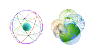
The geodetic supply chain is the network of people, technologies, and organizations that together create and maintain accurate positioning and spatial data for global use — from satellites in orbit to surveyors on the ground. The worldwide geodetic supply chain is coordinated through international organizations like the UN-GGIM and the International Association of Geodesy. They define global reference systems such as the International Terrestrial Reference Frame (ITRF). Satellite constellations like GPS, Galileo, and BeiDou form the core infrastructure for positioning data. Ground-based reference stations and observatories maintain and calibrate these systems. Regional and global data centers process and distribute accurate geodetic data worldwide. National mapping agencies apply these standards locally to create coordinate systems and maps. Private companies such as Trimble, Esri, and Leica provide the technology and tools to use this data. Training centers and universities educate the professionals who operate within this ecosystem. This collaboration ensures reliable positioning and mapping for science, infrastructure, and navigation. Together, these layers create a seamless global network that powers the modern geospatial world.

Choosing to further your education is an important decision—and understanding your goals is key. At Geo-ICT, we believe that personal satisfaction and a fulfilling job are the foundation for successful learning. That’s why we support professionals who are already working and want to grow further in their careers.

Our GIS master’s program is complemented by access to over 60 hands-on courses delivered in small group settings. This allows for meaningful interaction with experienced instructors and peers from the field, helping you build both skills and a strong professional network.

You’ll also benefit from personalized support. Our study coaches and instructors—many of whom have completed the master’s themselves—provide ongoing guidance throughout your learning journey. We also help you continuously improve your CV, aligning it with the ECTS credits you earn and the practical experience you gain along the way.

Curious to learn more? Reach out to us at info@geo-ict.com.

Geo-ICT Training Center International collaborates with leading recruitment platforms and hiring desks for remote GIS positions worldwide. Through partnerships with well-known platforms such as LinkedIn, Indeed, ZipRecruiter, and FlexJobs, they connect trained geo-professionals with global opportunities.
They also work with specialized GIS job boards like GIS Jobs Clearinghouse and Working Nomads to reach niche markets in the geospatial field. For freelance and project-based work, Geo-ICT International utilizes platforms such as Upwork and other global contracting networks. These collaborations allow their trainees and graduates to find suitable roles in GIS, GeoAI, remote sensing, and data analysis across different countries. By combining their blended learning model with access to remote job markets, they bridge education and international employment.
In this way, Geo-ICT International creates a global ecosystem where geo-professionals can learn, grow, and work anywhere in the world.