PointCloud Engineer

As a 3D scan operator, also known as a point cloud engineer, you play a key role in capturing the physical world and converting it into highly accurate digital models. Using advanced scanning technologies—such as laser scanners, drones, and photogrammetry—you create detailed 3D representations of buildings, objects, or landscapes. Your work supports industries from construction and architecture to heritage preservation and engineering.

What does 3D Scan Operator do?

As a 3D scan operator, you’re responsible for capturing real-world environments and transforming them into digital models. Your role combines technical precision with creativity, as you help lay the digital foundation for everything from infrastructure design to virtual reconstructions.

Here’s what your daily work includes:

  • Scan planning and preparation
    You carefully plan each scan by selecting the best positions and adjusting equipment settings. This ensures that every detail is captured with accuracy.
  • Performing scans
    Using laser scanners and photogrammetry tools, you conduct high-precision scans of buildings, objects, or environments.
  • Quality control
    After each scan, you check the data for accuracy and technical issues, making sure it’s clean and usable.
  • Data processing
    You convert raw scan data into point clouds and mesh models using specialized software.
  • Generating 3D models
    You bring the digital models to life by adding textures and refining the geometry to make the scan visually accurate and application-ready.

This role is not only technically challenging but also highly creative and impactful. Whether you’re contributing to a city renovation plan, supporting industrial design, or helping preserve historical landmarks, your work helps bridge the physical and digital worlds.

Geo-ICT Training Center, Nederland - Functie 3D-Scanoperator

Why your work matters

3D scanning is reshaping the way we design, build, and preserve our world. Your work as a scan operator is essential in industries that depend on precision, safety, and visualization. Here’s why it matters:

  • Precision and efficiency
    Your scans improve planning accuracy in construction, product design, and engineering—reducing errors and saving time.
  • Cultural preservation
    By documenting historical buildings and artifacts, you help protect cultural heritage for future generations.
  • Innovation in design
    Your data enables researchers, architects, and planners to create smarter, more sustainable solutions.
  • Safety and analysis
    In industries like infrastructure and energy, your scans help assess risk, monitor conditions, and improve safety planning.

You’re not just using a scanner—you’re capturing information that fuels better decisions, safer environments, and innovative ideas.

The role of geo-information in your work

Geo-information plays a central role in every step of the 3D scanning process. It gives your scans spatial context, allowing them to be accurately aligned, interpreted, and applied across projects. Here’s how geo-information supports your work:

  • Precise location tracking
    You use coordinates and mapping systems to determine the exact position of each scan point.
  • Efficient scan planning
    Geo-information helps you plan optimal scan paths, ensuring full coverage and reducing errors.
  • Analysis and modeling
    With geospatial data, you can place your models in a broader context—helping clients visualize how a scanned object or site fits into its environment.

Understanding and applying geo-information makes your work more accurate, efficient, and valuable across a range of sectors.

Request information


    What does the job involve?

    Your role as a 3D scan operator includes a wide range of tasks that contribute to creating reliable, detailed, and useful 3D models:

    • Planning and preparation
      You determine the best scan angles and setup locations based on project requirements and environmental factors.
    • Performing scans
      You operate advanced hardware—such as terrestrial laser scanners and photogrammetric cameras—to capture high-resolution spatial data.
    • Quality control and data processing
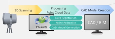
      You review, clean, and process raw scan data, transforming it into point clouds and digital meshes using industry-standard software.
    • Model creation and visualization
      You generate 3D models and apply textures, producing realistic visualizations that support a wide variety of applications.

    Your work is used in architecture, urban development, historical preservation, and even virtual reality environments. It’s technical, creative, and impactful—all at once.

    What do you need to get started?

    To become a successful 3D scan operator, you need both technical training and hands-on experience. At the Geo-ICT Training Center, we offer a complete learning path tailored to this role:

    • 3D scanning course – Learn how to operate laser scanners and photogrammetry equipment.
    • Surveyor training – Gain essential knowledge in land measurement and positioning.
    • Revit Architecture – Learn how to model scanned data into usable design structures.
    • Remote sensing – Understand how to interpret satellite and aerial data.
    • Drone surveying – Capture 3D data from the sky using unmanned aerial systems.

    This combination of training gives you the skills to collect, analyze, and model 3D data with precision and creativity.