In our increasingly data-driven world, geospatial data scientists play a vital role in shaping smart, efficient, and forward-thinking organizations. Here’s how your work creates real-world impact:
- Understanding customer behavior
By analyzing data tied to location and demographics, you help businesses optimize services, products, and marketing.
- Boosting efficiency
Your insights can improve operations—such as planning for preventive maintenance or optimizing delivery routes—saving time and money.
- Managing risk
You use predictive modeling to spot risks before they become problems, helping organizations act proactively rather than reactively.
- Driving innovation
Your models support the development of new tools and services that respond to today’s challenges—like smarter cities and climate resilience.
- Supporting strategy
The insights you provide guide strategic decisions across departments, giving companies a competitive edge in fast-changing markets.
By using data ethically and responsibly, you contribute to progress not only in business but in society as a whole.
How geo-information shapes your role
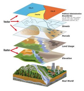
Geo-information adds a powerful spatial layer to traditional data analysis. It allows you to ask where something is happening—and why that location matters. By integrating coordinates, maps, and GIS data into your models, you uncover patterns that would otherwise go unnoticed.
Key applications include:
- GIS-based modeling
Geographic Information Systems allow you to combine multiple map layers—such as demographics, land use, and environmental data—for deeper spatial analysis.
- Disaster and risk planning
You can model the spread of natural disasters, assess vulnerabilities, and help plan emergency response strategies.
- Public health and sustainability
You might explore how environmental factors affect disease patterns or use geodata to support green infrastructure planning.
In the public and private sectors alike, geo-information makes your analysis more precise, your recommendations more relevant, and your impact more far-reaching.