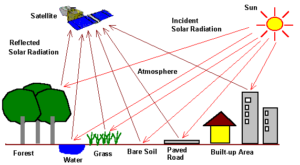
Remote sensing has become an essential tool for observing and understanding the Earth from a distance. By capturing information through sensors mounted on satellites and aircraft, it enables us to monitor the planet’s surface, atmosphere, and subsurface without direct contact. This technology plays a vital role in tracking environmental conditions, supporting land management, and informing decisions across various disciplines—from agriculture to climate science.
Its importance continues to grow across public and private sectors. Remote sensing supports large-scale environmental assessments, urban development, emergency response, and sustainable resource planning. At the heart of this method is the interaction between electromagnetic radiation and Earth’s surface, which allows us to detect features, track changes, and analyze patterns over time.
Geo-ICT’s Remote Sensing Course is designed to prepare professionals with both the theoretical foundation and practical expertise to work with remote sensing technologies. You’ll learn how to interpret satellite imagery, use multispectral data, and apply key analytical tools like Erdas Imagine. Whether you’re looking to deepen your knowledge or expand your capabilities in spatial analysis, this course offers the skills you need to succeed in a fast-evolving field.