Multi-Beam Survey

Geodesy

Explore the underwater world and gain hands-on experience with cutting-edge hydrographic tools. The Multi-Beam Survey Course from Geo-ICT gives you practical training in one of the most advanced seabed mapping techniques. In just four days, you’ll build a solid foundation in multi-beam sonar and develop the skills to conduct accurate, high-quality marine surveys—whether you're new to hydrography or expanding your geospatial expertise.

Course duration: 4 days

Taught by:

Stefan Smit
English

Introduction to Hydrography

Geo-ICT Training Center, The Netherlands - Multi Beam Survey

In hydrography—the science of measuring and mapping underwater environments—precision is everything. Whether it’s for maritime safety, offshore construction, environmental research, or coastal planning, understanding the seafloor is essential. As a result, multi-beam survey technology has become the go-to method for capturing high-resolution, 3D images of seabeds, riverbeds, and lakebeds.

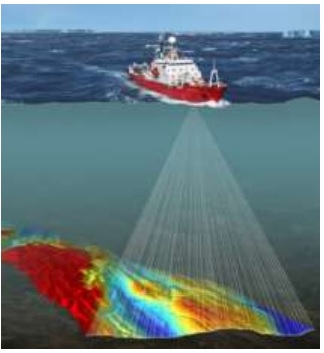
Unlike single-beam sonar, which scans a narrow line beneath the vessel, multi-beam systems use hundreds of sound beams at once. This allows surveyors to capture wide, detailed swaths of data in a single pass. Consequently, they can measure depth, identify underwater features, and build detailed digital maps. The data is essential for nautical chart creation, seafloor condition assessments, and even the discovery of archaeological sites and shipwrecks.

As climate change, coastal development, and marine exploration accelerate, so does the need for professionals skilled in hydrographic data collection and analysis. Today, environmental agencies, offshore companies, research institutions, and government bodies all rely on experts who understand both the theory behind sonar systems and the technical know-how to operate them in real-world conditions. For that reason, this course was designed to give you the practical and technical skills needed to succeed in this growing industry.

What will you learn

This course provides a complete introduction to the tools, workflows, and techniques used in multi-beam hydrography. To begin with, you’ll learn how to operate a multi-beam echosounder system, manage onboard calibrations, and maintain data quality from start to finish. In addition, you’ll gain experience planning surveys and producing accurate bathymetric maps.

Along the way, you’ll also discover how positioning systems, motion sensors, and specialized software integrate into a reliable workflow for marine data collection. By the end, you’ll understand not just how the tools work — but how to apply them effectively in field operations.

Why choose this course

At Geo-ICT, we don’t just teach tools — we help you build practical, job-ready skills. From day one, you’ll train with real equipment, gain hands-on experience, and work through scenarios that mirror real-world hydrographic projects.

Here’s what makes this course stand out:

  • Hands-on training with industry-standard tools, workflows, and datasets
  • Expert instruction from professionals in hydrography and geospatial analysis
  • Career-focused content aligned with roles in marine data, GIS, and environmental monitoring
  • Access to modern technology, including multi-beam sonar and advanced processing software

In short, this course equips you with the knowledge, tools, and confidence to excel in today’s hydrographic industry.

Read more

Enroll


    Group Discounts:
    10% for 3 participants
    15% for 4 or more participants


    Prices are indicative and may vary by country. Feel free to reach out — we’ll gladly work with you to find a suitable arrangement.

    €1795,- Excl. Vat

    €1795,- Excl. Vat

    Course structure

    Day 1

    You’ll kick off the course with the basics of multi-beam sonar — what it is, how it works, and why it’s become a critical tool in modern hydrography. Next, you’ll explore sonar technology, geodesy, and how client expectations influence survey design. After that, you’ll examine key equipment types, major manufacturers, and how to choose the right tools for different jobs. Finally, the day ends with an overview of survey software workflows and a first look at managing data quality during acquisition.

    Day 2

    The second day is all about bringing the survey vessel to life. To begin with, you’ll learn how to outfit the vessel with essential components, including GNSS systems, gyros, motion sensors, and sonar. Next, you’ll walk through vessel mobilization — connecting, aligning, and configuring your equipment. After that, you’ll dive into calibration and time synchronization techniques that ensure your data is accurate from the start. In short, the day focuses on building a solid technical foundation for reliable data acquisition.

    Geo-ICT Training Center, Nederland - cursus Multi beam survey


    Day 3

    With your setup ready, you’ll move into configuring and testing your systems. You’ll learn how to build a working setup in your survey software, interface it with hardware, and perform key system checks. You’ll also work with land-based methods like tide gauge reading and control point surveying to support accurate vertical referencing. The day ends with full system calibrations to ensure every component is survey-ready.

    Day 4

    On the final day, it all comes together. You’ll practice collecting real-time data using a simulator or actual recorded survey data, applying best practices throughout. As you gather data, you’ll monitor quality, troubleshoot issues, and use QA/QC tools to verify accuracy. Finally, you’ll clean and process the data using professional workflows, generate usable maps, and learn how to write a clear, effective survey report that meets client requirements.

    Course duration: 4 dagen
    Sign me up

    Learning Outcomes

    • Ability to operate multi-beam sonar systems for seabed and underwater mapping
    • Skills to calibrate and troubleshoot onboard sensors and systems
    • Competence in survey vessel setup and geospatial data acquisition workflows
    • Proficiency in using hydrographic software for data processing and visualization
    • Understanding of quality assurance processes and how to prepare survey deliverables
    • Confidence to work on or lead hydrographic survey projects in professional contexts

    More Information?

    Do you have questions about the course content? Not sure if the course aligns with your learning objectives? Or would you prefer a private session or in-company training? We’re happy to assist—feel free to get in touch.

    Frequently Asked Questions

    We aim to make our courses accessible to as many people as possible. If the course fee is a concern, instead of registering directly, you can indicate on the registration form that you’d like to receive a quote tailored to your needs. In many cases, we can offer flexible solutions. For instance, we can adjust the course content for large groups, shorten the course based on existing knowledge, or offer daily rates to suit your requirements.

    Yes, you can reach out to the instructor with questions for up to 2 weeks after the course. Since the instructor is likely teaching other courses, we recommend emailing your questions to info@geo-ict.com. We’ll forward your inquiry to the instructor, and you’ll receive a response within 24 hours. After the 2-week period, we recommend using our Personalized Online Support for continued assistance.


    Yes, we offer on-site training regularly throughout the Netherlands. Our instructor will bring laptops for the participants, and all you need to do is arrange a suitable room at your location.

    Please send your requirements to info@geo-ict.com, and we will provide a customized quote, which will include travel and accommodation costs. Once the quote is confirmed, our course coordinator will reach out to schedule the training days.

    After each course, participants receive a link to our evaluation portal where you can share your feedback on what you liked and didn’t like. We strive to provide a great experience for all our participants, but if you have a complaint, please click on ‘Complaints Procedure’ in the portal. This document will guide you through the steps to take. Geo-ICT Training Center, Netherlands, is a member of the Dutch Council for Training and Education (NRTO), ensuring a fair and transparent process.

    Courses are typically scheduled according to the Dutch time zone, with sessions running from 9:00 AM to 12:00 PM and 1:00 PM to 4:00 PM. For participants in different time zones, we adjust the course times in consultation with you.