Looking to learn more about ArcGIS?

Lijntekening met een computerscherm in het middel, met daarop een geografische kaart. En daaromheen geografische objecten. Gemaakt door DallE.

Why ArcGIS?

ArcGIS is one of the most powerful and widely used Geographic Information System (GIS) platforms in the world. It allows professionals to visualize, analyze, and interpret spatial data with precision and depth. While GIS as a concept supports smarter decision-making across industries, ArcGIS is the industry standard that brings those capabilities to life.

From urban development to disaster management, ArcGIS helps users unlock insights, solve complex problems, and drive impactful results.

Geo-ICT Training Center, The Netherlands - ArcGIS Courses

ArcGIS Courses at Geo-ICT Training Center, The Netherlands

If you want to gain practical, job-ready skills in ArcGIS, the Geo-ICT Training Center is your ideal starting point. Our courses focus on applied knowledge and real-world impact.

Want to explore course options now?
Start with our ArcGIS Basics course—ideal for anyone new to GIS—or take your skills further with ArcGIS 3D, where you’ll learn to visualize spatial data in three dimensions.

Why learn ArcGIS with us?

  • Expert instruction
    Learn from professionals who work with ArcGIS every day.
  • Hands-on training
    Apply what you learn through exercises that reflect real scenarios.
  • All skill levels supported
    Whether you’re a beginner or ready to specialize, there’s a path for you.
  • Career-oriented learning
    Our training equips you to stand out in a competitive, GIS-driven job market.

Real-world applications of ArcGIS

ArcGIS is used globally to solve problems and optimize operations across sectors:

  • Urban planning: Design data-driven cities.
  • Environmental science: Track changes and plan interventions.
  • Crisis management: Map risk and improve emergency response.
  • Agriculture: Support precision farming with geospatial insights.
  • Logistics: Optimize transport networks in real time.
  • Healthcare: Improve services and monitor public health trends.

These are just a few of the many areas where ArcGIS makes a difference.

Boost Your Career with ArcGIS

Mastering ArcGIS opens doors to exciting opportunities. Whether you’re aiming to advance in your current role or shift into a high-demand career, ArcGIS gives you a competitive edge. You’ll gain skills that are applicable to real-world projects, from urban development to climate action. In a world driven by data, ArcGIS expertise is a future-proof asset—empowering you to make an impact across industries like tech, infrastructure, and the environment.

Ready to get started?

Explore our full course catalogue and take the first step toward transforming your career with GIS.

Start your GIS journey today – enroll in an ArcGIS course now!

Need more information?

Frequently asked questions about our GIS course

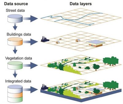
GIS, or Geographic Information Systems, is a technology that allows us to collect, manage, analyze, and visualize spatial and geographic data. It is used in various sectors for map creation, spatial analysis, and decision-making processes.

Our courses are aimed at emerging geo-specialists, experienced geo-professionals, companies in the geosector, career changers, and educational institutions looking to expand or refresh their GIS knowledge.

Mastering GIS technologies can transform your career by increasing your employability in various sectors such as urban planning, environmental science, and logistics. It provides the skills to analyze and visualize complex geographic data.

Yes, after successfully completing your course, you will receive a certified certificate of completion. This certificate is an acknowledgment of the skills and knowledge you have gained in GIS.

GIS has a wide range of applications across various sectors. We offer courses focused on specific industries and roles, allowing you to integrate GIS into your work, from data analysis to spatial planning.

Yes, we offer tailored solutions specifically designed to meet the needs of your company. These can range from introductory courses to advanced applications of GIS technology.