Looking to take a course on GeoAI?

Why GeoAI Matters

Geo-ICT Training Center - GeoAI

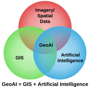
GeoAI—Geospatial Artificial Intelligence—combines the power of location-based data with artificial intelligence to solve complex challenges faster and smarter. By applying machine learning and deep learning to geospatial datasets, GeoAI enables advanced analysis, automation, and decision-making across sectors like urban planning, climate science, public health, and logistics.

From predicting urban growth to improving emergency response systems, GeoAI is transforming how professionals use spatial data. As digital transformation accelerates across Europe, GeoAI skills are becoming essential in both public and private sectors.


GeoAI Courses at Geo-ICT Training Center, The Netherlands

At Geo-ICT, we offer practical GeoAI training that bridges geospatial knowledge with modern AI techniques. Whether you’re just starting out or looking to specialize in spatial data science, our courses help you build real, job-ready skills.

Want to explore course options now?
Start with our Spatial Data Science with QGIS course to learn how to analyze spatial patterns and trends using open-source GIS tools. Or take your skills further with Deep Learning in ArcGIS, where you’ll apply advanced AI techniques to automate mapping and extract insights from complex geospatial data.

Why train with us?

  • Real-world application
    Learn how to apply AI techniques to geospatial problems using tools like Python, ArcGIS, and QGIS.
  • Project-based learning
    Gain hands-on experience through real datasets and practical case studies.
  • Flexible learning paths
    From AI fundamentals to advanced deep learning with spatial data—there’s a course for every level.
  • Career-focused skills
    Prepare for roles in smart cities, environmental monitoring, mobility, and more.

Real-World Applications of GeoAI

GeoAI is already making an impact across industries:

  • Urban planning: Analyze growth patterns and design smarter infrastructure.
  • Agriculture: Monitor crops and optimize yields with drone and satellite data.
  • Healthcare: Use spatial data to improve diagnostics and access to care.
  • Mobility: Predict traffic flows and optimize transportation routes.
  • Disaster response: Automate risk mapping and real-time response planning.

These examples show how AI and geospatial data together drive faster, more informed decisions.

Boost Your Career with GeoAI Skills

GeoAI sits at the intersection of two fast-growing fields—AI and geospatial analysis. With Geo-ICT, you’ll learn how to work with machine learning, deep learning, and location intelligence tools, giving you an edge in industries focused on sustainability, urban innovation, logistics, and beyond.

Whether you’re developing smart solutions or streamlining existing systems, GeoAI skills will position you for future-ready roles in an increasingly data-driven world.

Ready to get started?

Explore our full course catalogue and take the first step toward transforming your career with GIS.

Advance your GIS career with expert-led GeoAI training from Geo-ICT.

Need more information?

Frequently asked questions about our Artificial Intelligence (AI) courses

GeoAI refers to the integration of Artificial Intelligence (AI) with Geographic Information Systems (GIS) to analyze and interpret spatial data. It is important because it enables the automation of complex geospatial analysis, improves decision-making in fields like urban planning, disaster management, and environmental conservation, and helps uncover patterns and insights that were previously undetectable.

Geo-ICT offers a unique combination of theoretical knowledge and hands-on experience, focusing on real-world applications of AI, particularly in spatial and data-driven contexts. With expert instructors, a diverse course catalog, and a community of like-minded learners, Geo-ICT equips you with the skills to innovate and excel in the evolving technology landscape.

Geo-ICT provides beginner-friendly courses such as Artificial Intelligence Fundamentals, Data Literacy, and Data Visualization. These courses establish a strong foundation in AI concepts and data processing, making them ideal for those starting their journey in AI.

GeoAI plays a critical role in addressing global challenges like climate change, urbanization, and disaster response. By analyzing massive geospatial datasets, GeoAI helps in creating sustainable energy models, planning resilient cities, and providing real-time solutions during natural disasters.

GeoAI has transformative impacts across various industries, including:

    • Environmental Protection: Monitoring deforestation and climate patterns.
    • Urban Planning: Optimizing infrastructure and transportation systems.
    • Healthcare: Mapping disease outbreaks and improving access to care.
    • Agriculture: Precision farming and crop health monitoring.
    • Retail: Location-based customer behavior analysis.

GeoAI continues to unlock new opportunities in these and many other sectors, making it a valuable skill for professionals aiming to lead in innovation.