Looking to take courses on ETL?

Afbeelding van een technische tekening die omhoog komt uit papier, in 3D. Gemaakt met DallE.

Why ETL Matters in Geoinformation

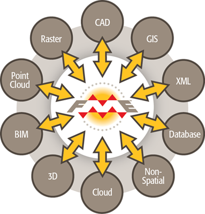
ETL—Extract, Transform, Load—is a core process in managing complex spatial data. It helps you gather information from multiple sources, convert it into usable formats, and load it into GIS platforms, cloud systems, or databases.

In the geospatial field, tools like FME (Feature Manipulation Engine) make ETL workflows faster, smarter, and more automated. With FME, you can handle hundreds of data formats, automate conversions, and streamline tasks across infrastructure, planning, and environmental projects.

If you work with spatial data, mastering ETL and FME means better performance, fewer errors, and more time for high-impact analysis.

Geo-ICT Training Center - category ETL courses

ETL & FME Courses at Geo-ICT Training Center, The Netherlands

At Geo-ICT, we offer hands-on ETL training focused on real-world geospatial needs. Whether you’re new to FME or looking to master advanced workflows, our expert-led courses help you build practical, in-demand skills.

Want to explore course options now?
Start with our FME Form Basics course to learn how to build and automate ETL workflows for spatial data using one of the most powerful tools in the industry. Or take a more technical approach with GDAL, where you’ll work with command-line tools to convert, process, and analyze raster and vector datasets.

Why train with us?

  • Geospatial focus
    Learn how to integrate and transform data for GIS, BIM, CAD, and database platforms.
  • Hands-on learning
    Build ETL workflows using real data and automate tasks with FME Desktop or FME Server.
  • Industry-ready skills
    Boost your career with technical knowledge used across urban planning, infrastructure, and public services.

Real-World Applications of ETL in GIS

ETL and FME skills are essential for data-intensive projects across industries:

  • Urban planning: Automate data imports for land use and zoning analysis.
  • Environmental monitoring: Convert sensor and satellite data into usable insights.
  • Infrastructure management: Migrate data between CAD and GIS platforms.
  • Public sector IT: Streamline workflows between departments and systems.

With FME, you can reduce manual work, ensure data consistency, and support smarter decision-making.

Boost Your Career with FME and ETL Skills

ETL expertise—especially when combined with powerful tools like FME—is increasingly in demand across the geospatial industry. Professionals who can manage, transform, and integrate data are essential to modern workflows, whether they’re GIS specialists, data engineers, or system developers. At Geo-ICT, you’ll learn how to automate repetitive tasks, streamline system migrations, and support cloud-based data transitions. You’ll also build the skills needed to bridge the gap between spatial teams and technical departments, unlocking new opportunities in data integration and geospatial development. Whether you’re aiming to grow in your current role or pivot into a new one, mastering ETL gives you a clear competitive advantage.

Ready to get started?

Explore our full course catalogue and take the first step toward transforming your career with GIS.

Advance your GIS career with expert FME and ETL training.

Register now!

Frequently Asked Questions about our ETL

ETL stands for Extract, Transform, and Load, which is a data integration process used to consolidate data from multiple sources into a centralized data repository, like a data warehouse or a database. The ETL process consists of three main stages:

  1. Extract: Retrieve data from various sources, such as databases, APIs, files, or cloud storage.
  2. Transform: Clean, enrich, and modify the data to fit the desired format or structure, applying business rules or removing inconsistencies.
  3. Load: Store the transformed data into the target system for analysis or operational use.

ETL is commonly used in data engineering, analytics, and business intelligence workflows.

FME (Feature Manipulation Engine) is a powerful and flexible data integration platform designed specifically for working with spatial and non-spatial data. It is widely used for Extract, Transform, and Load (ETL) processes involving geospatial data, allowing users to efficiently transform and integrate data from different sources and formats. To get a good start with FME, we recommend the course: FME Forms.