Get hands-on with one of the most powerful tools in modern surveying. In this practical course from Geo-ICT, you'll learn how to process, adjust, and analyze geodetic networks using MOVE3D—boosting both your precision and your confidence.
Geodesy
Get hands-on with one of the most powerful tools in modern surveying. In this practical course from Geo-ICT, you'll learn how to process, adjust, and analyze geodetic networks using MOVE3D—boosting both your precision and your confidence.
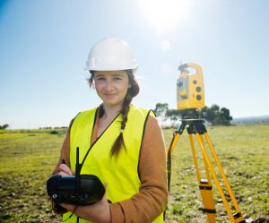
Surveying is the backbone of how we plan, build, and manage the physical world. From defining property boundaries to guiding the construction of infrastructure, it ensures that every measurement is accurate and every decision is built on solid ground. While traditional techniques have been used for centuries, today’s surveyors rely on advanced tools that bring a new level of precision to the job.
One of those tools is MOVE3D, a specialist software platform used to analyze and adjust geodetic networks in one, two, or three dimensions. Based on the Delft method of least-squares adjustment, MOVE3D allows professionals to refine survey data, detect and correct errors, and produce highly accurate results. It’s trusted in projects ranging from large construction sites and pipeline installations to underwater surveying and high-precision monitoring.
At Geo-ICT, we know how vital it is to stay ahead in a field that’s becoming more technical by the day. That’s why we’ve created this course specifically for professionals who want to deepen their understanding of survey adjustments and get hands-on experience with MOVE3D. If you’ve already taken our Surveying Basics course, this is your ideal next step to mastering network analysis and producing flawless survey results.
This course walks you through both the theory and practice of survey adjustments using MOVE3D. You’ll begin by learning how geodetic networks function in 1D, 2D, and 3D, and why adjustments are necessary to refine and validate raw survey data. With MOVE3D as your main tool, you’ll learn how to import data, manage measurement files, and identify common errors that affect accuracy.
Next, you’ll dive into the core of the software—adjusting networks using the least-squares method. You’ll explore how to apply these calculations in real projects, make sense of residuals and error ellipses, and interpret adjustment results. Throughout the course, you’ll work with real datasets, giving you a practical sense of how to use the software in fieldwork and project environments.
As the course progresses, you’ll move into automation and integration. You’ll learn how to create scripts to speed up repetitive tasks, combine GNSS data with total station measurements, and export results to GIS and CAD platforms. You’ll also complete a final project, working through a full adjustment workflow from raw data import to final report creation. By the end of the course, you’ll not only know how to use MOVE3D—you’ll know how to make it work for you in real-world scenarios.
If precision, efficiency, and quality are important in your work, this course will give you the skills to deliver them consistently. Here’s why surveyors and geodata professionals choose Geo-ICT’s MOVE3D course:
You’ll start with a course introduction and an overview of survey theory, focusing on the basics of 1D, 2D, and 3D geodetic networks. You’ll get familiar with the MOVE3D interface, learn how to import survey data, and perform your first network visualizations. Then, you’ll apply least-squares adjustments to a simple 2D network.
We’ll review Day 1 and move into advanced adjustment techniques. You’ll dive deeper into the theory of least-squares adjustment and error propagation, then apply these concepts to a complex 3D network. You’ll practice identifying and correcting errors, visualizing error ellipses, and interpreting adjustment outcomes. By the end of the day, you’ll know how to create professional reports and summaries of your results.
You’ll learn how to automate your workflow in MOVE3D by writing scripts for repetitive tasks like data imports and adjustments. You’ll work on combining GNSS data with total station measurements, and practice exporting final datasets to GIS and CAD platforms. The course wraps up with a full project: from data import to final adjustment and reporting—putting all your new skills into practice.

Do you have questions about the course content? Not sure if the course aligns with your learning objectives? Or would you prefer a private session or in-company training? We’re happy to assist—feel free to get in touch.
The MOVE3D course is a specialized training program designed to teach professionals how to use MOVE3D, a powerful software tool for geodetic analysis and network adjustments. MOVE3D is commonly used in land surveying, geodesy, and related fields to process and adjust geodetic measurements, allowing for precise calculation of coordinates and spatial relationships in 2D, 3D, and 1D geodetic networks.
The MOVE3D course is intended for:
This course is suitable for anyone involved in geodetic analysis, surveying, and the processing of accurate geospatial data who wishes to develop advanced skills using MOVE3D software.
In the Netherlands, MOVE3D is sold and distributed by Sweco Nederland B.V., a leading engineering and consultancy firm. They handle the sales, support, and distribution of MOVE3D software, which is widely used for geodetic network adjustments and quality control in surveying projects. You can get a demo version here: https://move3software.com/downloads/