FME Form Basics

ETL

ETL

Take control of your data with FME Form Basics, a hands-on course from Geo-ICT that introduces you to one of the most powerful tools for data transformation and integration: FME (Feature Manipulation Engine). Whether you're converting file formats, automating workflows, or cleaning up datasets, this course gives you the practical skills to manage and manipulate data from almost any source. With a strong focus on real-world applications, you’ll gain the knowledge and confidence to use FME effectively in your daily work.

Course duration: 2 days

Taught by:

TBD
English

FME 

Geo-ICT Training Center, The Netherlands - Course FME Desktop Basics

Data is everywhere—and it’s growing faster than ever, both in size and variety. For professionals working with spatial, structured, or system-based data, managing all these formats and sources can be a challenge. That’s where FME Form (formerly FME Desktop) comes in. Created by Safe Software, FME is a visual data integration platform that lets you transform, combine, and automate data workflows—no coding required.

What makes FME so powerful is its flexibility and ease of use. It supports hundreds of data formats, from GIS and CAD files to spreadsheets, databases, and cloud services. Using a simple drag-and-drop interface, you can build automated workflows that clean, reformat, and integrate your data. With over 500 built-in transformers, FME lets you customize your process—whether you’re converting basic file types or performing complex spatial analysis.

FME is widely used by GIS specialists, data analysts, engineers, and IT professionals who need to streamline data management and improve the quality of their results. At Geo-ICT, we’ve designed this course not just to teach you the software, but to show you what’s possible. You’ll walk away with the skills to solve data problems more efficiently and work smarter across all your projects.

What you will learn

This course takes you from the basics to real-world application. You’ll begin by exploring the FME Form interface and learning how to configure readers and writers—the core building blocks used to import and export data. You’ll use the FME Data Inspector to examine the geometry and attributes of your data before processing begins. Early hands-on tasks include modifying and creating attributes, filtering datasets, and connecting data from different sources.

As the course progresses, you’ll build your first translations using key transformers like the Tester, AttributeManager, and FeatureMerger. You’ll also learn how to organize your workspace with bookmarks and annotations, and set up coordinate systems correctly to ensure accuracy in your results.

By the second day, you’ll work with more advanced tools. You’ll import open datasets, perform spatial analyses, and calculate totals and averages using transformers such as Bufferer, Aggregator, and Areacalculator. These exercises will help you build efficient, automated workflows tailored to your specific data needs.

You’ll also explore how to handle data quality checks, integrate web services, and prepare data for mapping and analysis. By the end of the course, you’ll be confident in your ability to build FME workflows from scratch and solve complex data challenges independently.

Why choose this course

Geo-ICT’s FME Form Basics course is built for professionals who want to apply FME in real work environments, not just learn the theory. Here’s why people choose us:

  • Expert instructors with real-world FME experience guide you through both the basics and practical use cases
  • Hands-on training ensures you learn by doing, not just watching
  • Up-to-date content covers the latest features in FME Form
  • Career-focused outcomes prepare you to use FME directly in your projects or workplace
Read more

Sign up


    Group Discounts:
    10% for 3 participants
    15% for 4 or more participants


    Prices are indicative and may vary by country. Feel free to reach out — we’ll gladly work with you to find a suitable arrangement.

    €895,- Excl. btw

    €895,- Excl. btw

    Course structure

    Day 1

    You’ll begin with an introduction to FME Form and get familiar with the user interface. You’ll configure readers to import data and use the Data Inspector to explore file contents and structures. Then, you’ll start designing simple workflows using common transformers like Tester, Sorter, PointonAreaOverlayer, AttributeManager, and FeatureMerger. By the end of the day, you’ll be able to inspect, clean, and connect data from multiple sources and prepare it for output.

    Day 2

    On the second day, you’ll shift your focus to workflow design and spatial transformation. You’ll learn how to use bookmarks and annotations to organize your workspace and improve readability for collaboration. You’ll also explore how to configure coordinate systems and perform more advanced spatial analyses. Tasks include importing open datasets via WMS and WFS, calculating spatial metrics, and building more complex workflows using transformers like Sampler, Bufferer, Aggregator, Areacalculator, Featurereader, and Featurewriter. By the end of the day, you’ll have the skills to design and run your own automated data workflows.

    Course duration: 2 days
    Schrijf mij in

    Learning Outcomes

    • Understand and apply the core principles of FME Form for data transformation and integration.
    • Import, inspect, transform, and export data in various formats using readers, writers, and transformers.
    • Work with diverse data types—including GIS, CAD, raster, and tabular formats—and integrate them in one workflow.
    • Design clean, reusable, and organized workspaces with clear structure and logic.
    • Perform spatial analysis, clean data, and run attribute transformations using FME’s visual tools.
    • Automate repetitive data workflows to improve efficiency, accuracy, and data consistency.

    More Information?

    Do you have questions about the course content? Not sure if the course aligns with your learning objectives? Or would you prefer a private session or in-company training? We’re happy to assist—feel free to get in touch.

    Frequently Asked Questions about FME Desktop

    FME Desktop (Feature Manipulation Engine) is a powerful software platform designed for data integration, transformation, and automation. Developed by Safe Software, FME Desktop enables users to manipulate and convert data from various formats, applications, and systems. It is widely used in industries like GIS (Geographic Information Systems), engineering, and data management to streamline workflows involving spatial and non-spatial data.

    FME Desktop can greatly assist with data integration by enabling users to efficiently combine, transform, and harmonize data from various sources and formats into a unified, usable dataset. Here are some specific ways it supports data integration:

    1. Support for Multiple Data Formats

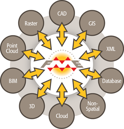
    FME Desktop supports over 450 different file formats, such as GIS, CAD, XML, JSON, as well as databases, spreadsheets, and more. This versatility allows it to integrate data from diverse systems and platforms, removing barriers typically caused by incompatible formats.

    2. Data Transformation

    FME Desktop offers more than 500 transformers, which are tools designed to modify, clean, and validate data. These transformers help users standardize, enrich, or restructure data, making it possible to seamlessly integrate datasets that have varying structures or schemas.

    3. Data Validation and Cleansing

    FME Desktop allows users to identify and fix data inconsistencies during the integration process. Users can apply filters, validation checks, and transformation rules to ensure the data being integrated is accurate, clean, and conforms to the required standards.

    4. Spatial and Non-Spatial Data Integration

    FME Desktop excels in combining spatial (geographic) and non-spatial data. This is particularly useful in industries like GIS, where data from CAD drawings, satellite imagery, or database systems needs to be integrated for spatial analysis and visualization.

    5. Automating Data Integration Workflows

    Users can create automated workflows in FME Desktop to streamline recurring data integration tasks. These workflows can be scheduled or triggered to run automatically, ensuring that integrated data is updated regularly without manual intervention.

    6. Coordination Across Systems

    FME can act as a bridge between different data systems, facilitating communication between platforms like cloud services (e.g. AWS, Google Cloud), databases (e.g. PostgreSQL, Oracle), and other enterprise systems. This capability enables the integration of data from disparate sources into a unified environment for analysis and decision-making.

    7. Spatial Data Manipulation

    FME Desktop is particularly strong at integrating spatial data by converting projections, handling coordinate transformations, and managing geometry. This helps merge geographic datasets with attribute data from other systems, providing deeper insights.

    8. No-Code Environment

    FME’s visual, drag-and-drop interface makes data integration accessible even to users without programming skills. Complex workflows can be designed without writing code, making it easier for teams to collaborate and integrate data efficiently.