Deep Learning in QGIS

GeoAI

Unlock the power of deep learning in your geospatial workflows. In this hands-on, project-based course, you’ll learn how to use QGIS to apply neural networks for tasks like image classification, object detection, and pattern recognition. Whether you're working in environmental science, urban planning, or infrastructure analysis, this course gives you the tools to automate processes and extract insights from complex spatial data.

Course duration: 2 days

Taught by:

TBD
English

Deep Learning and QGIS

Geo-ICT Training Center, Netherlands - Deep Learning in ArcGIS Pro

Deep learning — a powerful branch of machine learning built on multi-layered neural networks — is changing how we analyze and understand geospatial data. By mimicking the way the human brain recognizes patterns, deep learning enables computers to detect subtle features in satellite imagery, classify land cover, and identify objects with exceptional precision.

Within GIS, this technology is unlocking new levels of efficiency. It can automate time-consuming tasks like mapping infrastructure, monitoring environmental change, and detecting objects across vast landscapes. What once took hours or days to process can now be completed in minutes — and often with greater accuracy.

This matters more than ever. As the volume of spatial data grows — from drones, satellites, and IoT sensors — so does the need for faster, smarter analysis. Urban planners use deep learning to track land use. Conservationists monitor deforestation trends. Disaster response teams map wildfire impact zones in near real-time. In each case, deep learning provides faster insights and supports better decisions.

Thanks to tools like QGIS and its robust plugin ecosystem, deep learning is no longer confined to data science labs or expensive proprietary platforms. It’s now accessible to GIS analysts, planners, researchers, and engineers working on real-world challenges. By combining spatial intelligence with the analytical power of AI, you can approach complex problems with confidence, clarity, and speed.

What will you learn

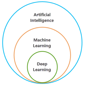
This course offers a hands-on, practical introduction to deep learning in QGIS. You’ll start by exploring the basics of neural networks — how they work, how they’re built, and why they’re so effective in spatial analysis. Then, you’ll dive into real-world projects where you collect data, train models, and perform deep learning tasks directly in QGIS.

You’ll learn how to:

  • Prepare and label geospatial data for training
  • Use QGIS plugins to build and fine-tune deep learning models
  • Apply your models to classify imagery, detect objects, and segment land cover
  • Analyze large datasets using automation
  • Communicate results through clear maps and visualizations

By the end of the course, you’ll be ready to apply deep learning to support smarter, faster decision-making in fields like infrastructure planning, environmental monitoring, or disaster response.

Why choose this course

At Geo-ICT, we believe advanced technology should be accessible, practical, and directly tied to real-world impact. That’s why this course is built around applied learning — not just theory.

Here’s what makes it stand out:

  • Learn by doing: Every concept is applied in exercises drawn from real scenarios
  • Expert guidance: Taught by professionals with deep experience in both AI and GIS
  • Open-source tools: No expensive licenses — just QGIS, plugins, and your curiosity
  • Relevant and future-ready: Gain skills that are in high demand across industries

Whether you’re new to deep learning or looking to take your GIS skills to the next level, this course provides a smart, approachable path into AI-powered spatial analysis.

Read more

Enroll


    Group Discounts:
    10% for 3 participants
    15% for 4 or more participants


    Prices are indicative and may vary by country. Feel free to reach out — we’ll gladly work with you to find a suitable arrangement.

    €1095,- Excl. Vat

    €1095,- Excl. Vat

    Course structure

    Day 1

    We begin with the fundamentals of deep learning and how it fits into geospatial analysis. You’ll learn how neural networks work, how to prepare training data, and how to label imagery for classification tasks. By the end of the day, you’ll build and run your first classification model using QGIS.

    Day 2

    On day two, you’ll move into more advanced techniques like object detection and model evaluation. You’ll explore best practices for training accuracy, and apply your model to real satellite or drone imagery. The course concludes with a capstone project that challenges you to apply everything you’ve learned to a real-world use case.

    Course duration: 2 dagen
    Sign me up

    Learning Outcomes

    • Understand deep learning fundamentals and neural network architecture
    • Collect, prepare, and label spatial data for classification and detection
    • Train and apply deep learning models in QGIS
    • Analyze satellite imagery and extract features automatically
    • Create visualizations that clearly communicate your results
    • Use AI to automate analysis and support faster, smarter decision-making

    More Information?

    Do you have questions about the course content? Not sure if the course aligns with your learning objectives? Or would you prefer a private session or in-company training? We’re happy to assist—feel free to get in touch.

    Frequently Asked Questions

    We aim to make our courses accessible to as many people as possible. If the course fee is a concern, instead of registering directly, you can indicate on the registration form that you’d like to receive a quote tailored to your needs. In many cases, we can offer flexible solutions. For instance, we can adjust the course content for large groups, shorten the course based on existing knowledge, or offer daily rates to suit your requirements.

    Yes, you can reach out to the instructor with questions for up to 2 weeks after the course. Since the instructor is likely teaching other courses, we recommend emailing your questions to info@geo-ict.com. We’ll forward your inquiry to the instructor, and you’ll receive a response within 24 hours. After the 2-week period, we recommend using our Personalized Online Support for continued assistance.


    Yes, we offer on-site training regularly throughout the Netherlands. Our instructor will bring laptops for the participants, and all you need to do is arrange a suitable room at your location.

    Please send your requirements to info@geo-ict.com, and we will provide a customized quote, which will include travel and accommodation costs. Once the quote is confirmed, our course coordinator will reach out to schedule the training days.

    After each course, participants receive a link to our evaluation portal where you can share your feedback on what you liked and didn’t like. We strive to provide a great experience for all our participants, but if you have a complaint, please click on ‘Complaints Procedure’ in the portal. This document will guide you through the steps to take. Geo-ICT Training Center, Netherlands, is a member of the Dutch Council for Training and Education (NRTO), ensuring a fair and transparent process.

    Courses are typically scheduled according to the Dutch time zone, with sessions running from 9:00 AM to 12:00 PM and 1:00 PM to 4:00 PM. For participants in different time zones, we adjust the course times in consultation with you.