ArcGIS Basics

ArcGIS

ArcGIS

Build a solid foundation in Geographic Information Systems with the ArcGIS Pro 2D Basics course by Geo-ICT. Whether you're just getting started or refreshing your skills, this hands-on course introduces you to the powerful tools in ArcGIS Pro. You'll learn how to work with spatial data, create maps, and run basic analyses—all with the goal of turning raw geographic data into clear, useful insights. With expert guidance and real-world practice, you'll gain the confidence to apply GIS in your field.

Course duration: 3 days

Taught by:

Peter Schols

ArcGIS Pro

Geo-ICT Training Center, Nederland - Cursus ArcGIS Pro 2D Basis

Geographic Information Systems (GIS) help us make sense of location-based data. From planning new roads to protecting natural areas, GIS gives people across industries the tools to understand, map, and analyze the world around them. One of the most popular tools for this work is ArcGIS Pro, developed by Esri. It’s used worldwide for mapping, visualizing, and analyzing spatial data.

ArcGIS Pro goes far beyond drawing maps. It helps you manage geographic data, combine different data sources, and perform detailed spatial analyses. It’s a key platform for professionals working in urban planning, transportation, environmental protection, infrastructure development, and many more areas where location matters.

The ArcGIS Pro 2D Basics course from Geo-ICT is designed to give you a practical introduction to this essential software. With a focus on 2D mapping, you’ll learn how to use ArcGIS Pro to organize data, perform analyses, and create maps that clearly communicate your findings. If you’re starting out in GIS or transitioning from older tools like ArcMap, this course is the perfect place to begin. As more industries rely on spatial insights, having ArcGIS Pro skills puts you in a strong position to contribute and lead.

What you will learn

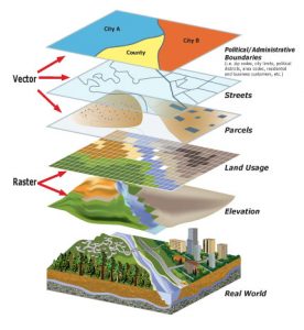
In this course, you’ll learn the core skills needed to work confidently with ArcGIS Pro. You’ll begin by getting familiar with the interface and learning how to navigate the platform with ease. As you progress, you’ll discover how to create and edit maps, add layers, and work with geographic data from various sources to build meaningful visualizations.

You’ll gain practical experience using tools like ModelBuilder, which allows you to automate repetitive tasks and run basic spatial analyses more efficiently. Along the way, you’ll develop the ability to organize, edit, and combine data to create clear and informative maps that support analysis and storytelling. You’ll also learn how to prepare your projects for sharing—whether through digital reports, exported maps, or collaborative workflows. By the end of the course, you’ll be able to take raw spatial data and transform it into professional-quality maps and insights that are ready to use in real-world scenarios.

Why choose this course

Geo-ICT’s ArcGIS Pro 2D Basics course is ideal for anyone who wants a strong, practical introduction to GIS. Here’s what makes it stand out:

  • Step-by-step instruction from GIS experts who know how to explain complex topics in simple terms
  • Practical focus with real-world data and exercises so you can apply your skills immediately
  • Current software and tools using the latest version of ArcGIS Pro
  • Clear learning path that prepares you for more advanced GIS and spatial analysis topics
Read more

Sign up


    Group Discounts:
    10% for 3 participants
    15% for 4 or more participants


    Prices are indicative and may vary by country. Feel free to reach out — we’ll gladly work with you to find a suitable arrangement.

    €1195,- Excl. btw

    €1195,- Excl. btw

    Course structure

    Day 1

    You’ll start with an introduction to ArcGIS Pro. After getting familiar with the interface, you’ll learn how to load maps from different sources and build your own. By the end of the day, you’ll be able to create and adjust basic 2D maps confidently.

    Day 2

    The second day focuses on working with data. You’ll learn how to display data on your maps, combine information from multiple sources, and begin using ModelBuilder to run simple spatial analyses. This day helps you start thinking about how GIS can solve real problems.

    Day 3

    On the final day, you’ll bring everything together. You’ll work with raster data and explore how to share your maps and results. There’s also a short introduction to 3D mapping. If you have your own use case or project, you’ll have time to explore it with help from the instructor. This day is about applying what you’ve learned and gaining the confidence to use ArcGIS Pro independently.

    Course duration: 3 days
    Schrijf mij in

    Learning Outcomes

    • Understand the ArcGIS Pro interface and main functions
    • Create and edit maps using data from various sources
    • Use ModelBuilder to automate and perform basic analyses
    • Work with raster layers and understand how they differ from vector data
    • Combine different types of geographic data into a single map
    • Organize, update, and manage spatial datasets
    • Analyze data to discover new patterns and insights
    • Relate tabular data to mapped features
    • Share maps, analysis results, and workflows with others
    • Get introduced to 3D mapping tools and concepts

    More Information?

    Do you have questions about the course content? Not sure if the course aligns with your learning objectives? Or would you prefer a private session or in-company training? We’re happy to assist—feel free to get in touch.

    Frequently Asked Questions about ArcGIS Pro

    This foundational course is designed to equip you with the skills to start working with ArcGIS confidently, whether for academic, professional, or personal projects.