What will you learn
This course gives you a step-by-step understanding of how to use 3D scanning to capture and model real-world objects and spaces. You’ll start with the basics of laser scanning—how scanners work, how to plan and perform a scan, and how to make sure your data is clean and accurate.
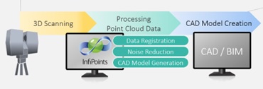
Next, you’ll dive into processing: transforming raw scan data into point clouds, and turning those point clouds into complete 3D models using tools like AutoCAD, Revit, and Recap. You’ll also learn about working with GIS platforms and how to choose the right software for different types of projects.
Throughout the course, you’ll practice working with actual scan data—first in the classroom, then out in the field. You’ll learn how to align multiple scans, handle large datasets, and produce 3D models that are both accurate and ready for use in real-world applications.
Why choose this course
At Geo-ICT, we believe learning should be hands-on, practical, and immediately useful. That’s exactly what you’ll get with our 3D scanning course. Whether you’re just starting out or looking to sharpen your skills, this course gives you the tools and confidence to turn scanned data into precise 3D models—ready for use in real projects.
- Learn by doing: Get started with professional 3D scanning tools and software from day one
- Guidance from experts: Our trainers have real-world experience and bring practical insight to every lesson
- Skills you can use right away: What you learn applies directly to architecture, engineering, construction, heritage preservation, and more
- Work with the right tools: Gain cross-platform experience using AutoCAD, Revit, and leading GIS systems