Geo-ICT International is the global branch of the Geo-ICT Training Center in the Netherlands. It focuses on providing blended learning programs that combine online study with live instructor sessions. Through these programs, participants gain both theoretical and practical Geo-ICT skills. The initiative connects international students and professionals with real-world Geo-ICT projects. Graduates are trained and then placed in GIS positions worldwide. This approach helps organizations find qualified specialists in GIS, GeoAI and spatial data. Training topics include GeoAI, remote sensing, drones, and spatial databases. The blended learning model ensures flexibility for global learners across time zones. Trainees receive guidance from experienced Dutch geo-professionals. Overall, Geo-ICT International bridges global education and employment in the spatial industry.
 The geodetic supply chain is the network of people, technologies, and organizations that together create and maintain accurate positioning and spatial data for global use — from satellites in orbit to surveyors on the ground. The worldwide geodetic supply chain is coordinated through international organizations like the UN-GGIM and the International Association of Geodesy. They define global reference systems such as the International Terrestrial Reference Frame (ITRF). Satellite constellations like GPS, Galileo, and BeiDou form the core infrastructure for positioning data. Ground-based reference stations and observatories maintain and calibrate these systems. Regional and global data centers process and distribute accurate geodetic data worldwide. National mapping agencies apply these standards locally to create coordinate systems and maps. Private companies such as Trimble, Esri, and Leica provide the technology and tools to use this data. Training centers and universities educate the professionals who operate within this ecosystem. This collaboration ensures reliable positioning and mapping for science, infrastructure, and navigation. Together, these layers create a seamless global network that powers the modern geospatial world.
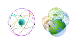