What does a GIS specialist do?
 As a GIS specialist, you work daily with geospatial data—gathering, processing, and interpreting information from maps, satellite images, and GPS sources. You use advanced GIS software like ArcGIS and QGIS to turn raw data into clear, visual tools that support complex decisions.
Your work typically involves:
- Urban planning
You create maps that show the most suitable locations for roads, buildings, or green spaces—based on factors like population density and existing infrastructure.
- Environmental management
You map and monitor areas of ecological value, track deforestation using satellite imagery, or assess flood-prone zones to support conservation.
- Logistics and mobility
You analyze traffic flow to reduce congestion and help plan more efficient public transport systems.
You also collaborate with urban planners, engineers, environmental experts, and policymakers—ensuring that spatial data plays a central role in solving real-world challenges.
Why your work matters
In today’s data-driven world, the ability to interpret and visualize spatial information is more valuable than ever. As a GIS specialist, you help connect geography with strategy—leading to smarter, more sustainable solutions.
Here’s why your work makes a difference:
- Conservation
You support climate resilience by mapping risk areas and contributing to disaster preparedness.
- Healthcare
You help track the spread of diseases or plan health services using geographic data.
- Agriculture
You analyze soil, weather, and terrain to help optimize crop yields and farming strategies.
Your work leads to:
- More efficient planning
- Lower operational costs
- Healthier, more sustainable communities
You don’t just make maps—you create tools that help people understand and improve the world around them.
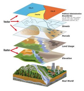
The impact of geoinformation on your role
Geoinformation is the foundation of your work. You combine layers of spatial data—topographic, environmental, demographic, and more—to gain insight into patterns, relationships, and trends that would otherwise remain hidden.
With these tools, you can:
- Detect problems early through spatial analysis
- Plan smarter cities and greener infrastructure
- Provide solutions for complex geographic challenges
Whether you’re analyzing satellite data or creating interactive maps, your expertise brings clarity and direction to important decisions.