GIS specialist

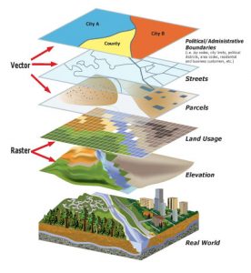
A GIS Specialist works with geographic information to analyze locations, create maps, and support decision-making for organizations. They contribute to projects in urban planning, utilities, environmental management, and logistics. Moreover, they develop skills in GIS software, spatial databases, and geodata processing tools, which makes this role both technical and dynamic.

What does a GIS Specialist do?

A GIS Specialist collects, organizes, and analyzes geographic data to solve spatial challenges. Most days involve digital tasks such as preparing datasets, creating maps, designing dashboards, and managing geodatabases. In addition, they run spatial analyses β€” for example, routing or suitability modeling β€” and collaborate closely with planners, engineers, and environmental experts to translate data into practical insights.

Although the role focuses mainly on computer work, they occasionally visit the field to verify data or gather new information. Furthermore, they communicate their results through reports, visualizations, and presentations, which helps teams make informed decisions. As a result, their workweek offers a clear mix of technical analysis, teamwork, and applied problem-solving.

In which professional areas are GIS Specialists needed?

  • Urban & regional planning
  • Environmental management
  • Utilities & infrastructure
  • Transport & logistics
  • Public safety & emergency services
  • Government & public administration
  • Real estate & property development

…and countless other sectors where location-based information plays an important role.

What are the reasons to become a GIS Specialist?

Many people choose this path because they enjoy understanding the world through spatial patterns and digital tools. A GIS career allows you to solve real challenges, such as designing greener cities, improving infrastructure, or protecting natural areas. Moreover, the role suits people who appreciate analytical work and like turning data into clear maps or visual explanations. If you value precision, enjoy learning new technologies, and want your work to have a visible impact on society, this profession naturally becomes a rewarding and motivating choice.

Read more

Request information

    Geo-ICT logo


    More Information?

    Do you have questions about the course content? Not sure if the course aligns with your learning objectives? Or would you prefer a private session or in-company training? We’re happy to assistβ€”feel free to get in touch.

    What do you need to get started?

    Background

    • Geography, GIS or Geomatics
    • Environmental science
    • Civil engineering
    • Urban planning
    • Or equivalent experience gained through projects or training

    Technical skills and possible trainings by Geo-ICTΒ 

    The future of a GIS Specialist

    The demand for GIS Specialists grows steadily, as organizations increasingly rely on spatial data for sustainability, mobility, infrastructure, and climate adaptation. Consequently, GIS expertise plays an essential role in smart-city development, renewable-energy planning, and digital-twin technologies. The profession offers a stable and future-proof career path with many opportunities to specialize β€” for example, in geospatial analytics, GIS development, data engineering, or remote sensing. Furthermore, companies in government, utilities, consulting, and tech continue expanding their geospatial teams, which strengthens long-term job security.

    FAQ career as GIS specialist

    If you have a university degree and already possess basic GIS knowledge from working with ArcGIS or QGIS, you can continue your professional development in a goal-oriented way at Geo-ICT Training Center, The Netherlands, through individual coaching and blended learning. Through our network, we can help you find a job in this growing geo-spatial market.

    GIS professionals can work in a wide range of fields, including urban planning, environmental management, transportation, public health, and natural resource management. Common roles include GIS analyst, GIS developer, cartographer, and spatial data scientist.

    GIS plays a crucial role in climate research and action. It helps scientists and policymakers visualize climate data, monitor environmental changes, and model future climate scenarios. GIS is also used to plan renewable energy projects, assess climate risks, and develop adaptation strategies for communities.

    Geo-ICT Training Center, The Netherlands - GIS and Climate