• Searching...

Result 61 - 72 of 87 courses

QGIS Geoserver

QGIS
  • Certified
  • Workload: 24 hour

QGIS Hydrology

QGIS
  • Certified
  • Workload: 24 hour

QGIS Landsat 8

QGIS
  • Certified
  • Workload: 24 hour

QGIS Mergin Field Data

QGIS
  • Certified
  • Workload: 24 hour

QGIS Mesh Data

QGIS
  • Certified
  • Workload: 24 hour

QGIS Models

QGIS
  • Certified
  • Workload: 24 hour

QGIS Open data

QGIS
  • Certified
  • Workload: 24 hour

QGIS Open Layers

QGIS
  • Certified
  • Workload: 24 hour

QGIS PCRaster

QGIS
  • Certified
  • Workload: 24 hour

QGIS Point Clouds

QGIS
  • Certified
  • Workload: 24 hour

QGIS Precision Agriculture

QGIS
  • Certified
  • Workload: 24 hour

QGIS Spatial Datascience

QGIS
  • Certified
  • Workload: 24 hour

Why choose a course at Geo-ICT Training Center, The Netherlands?

55

Courses

82

Blended Learnings

1200

Participants per year

What is Blended Learning?

Blended Learning is an educational approach that combines live, face-to-face online instruction with digital learning experiences. This approach integrates the strengths of both live virtual and self-paced digital environments to create a flexible, personalized learning experience for students.

Key components of Blended Learning include:

  1. Face-to-face instruction: Traditional teaching methods like lectures, discussions, and in-class activities.
  2. Online learning: Digital content delivered through video lessons, interactive modules, and online discussions.
  3. Student control: Learners have the flexibility to control the time, pace, path, or place of their learning through online components.

Blended learning is increasingly popular as it leverages technology to provide more individualized instruction, support diverse learning styles, and combine synchronous (real-time) with asynchronous (self-paced) experiences.
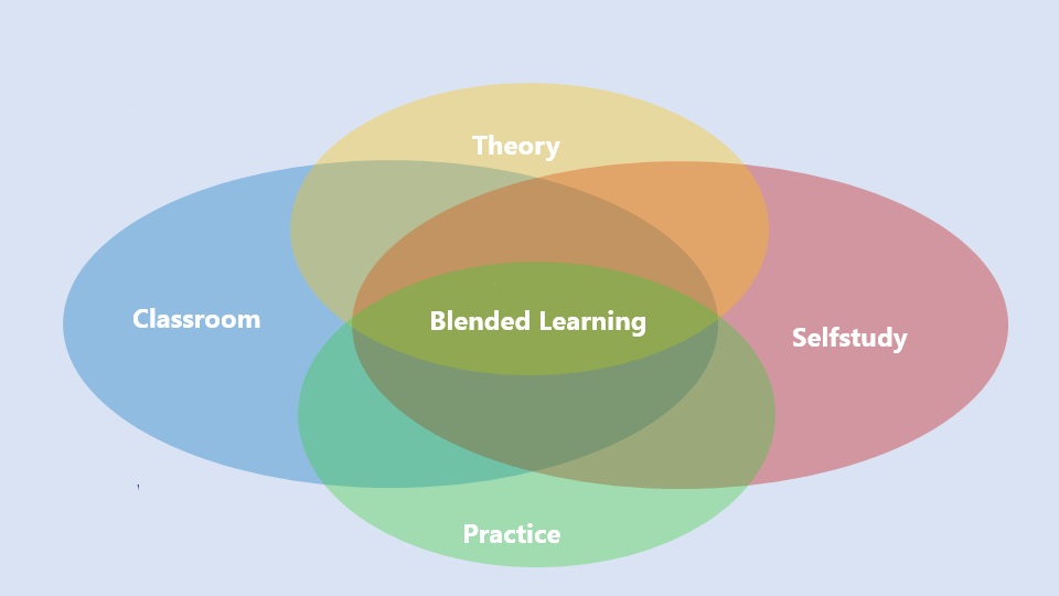
A Venn diagram with four overlapping ovals labeled "Classroom" (blue, left), "Selfstudy" (red, right), "Theory" (yellow, top), and "Practice" (green, bottom). At the center, where all four areas overlap, is "Blended Learning" shown in green. The image illustrates that blended learning is a combination of theory, practice, classroom instruction, and self-study.

In the QGIS and GeoServer course, you will learn how to combine the power of QGIS for geospatial data management and GeoServer for web-based GIS applications. Key topics include:

  • Introduction to GeoServer
  • Working with Spatial Data
  • Web Map Services (WMS) and Web Feature Services (WFS)
  • Advanced Styling with SLD
  • Data Integration
  • Creating Web Maps
  • Security and Configuration
  • Hands-On Projects

This course is ideal for GIS professionals, web developers, and data managers looking to leverage QGIS and GeoServer for spatial data publishing and web mapping applications.

This course teaches you how to install, configure, and use GeoServer to publish spatial data, while integrating QGIS for data preparation, styling, and analysis.

Basic familiarity with GIS concepts is helpful, but the course is designed to guide you step by step, making it accessible for both beginners and professionals.

You’ll use QGIS to prepare vector and raster datasets, create custom styles, and connect directly to GeoServer services for seamless workflows..

By the end of the course, you’ll be able to publish spatial data as web services, apply SLD styles, manage access and security, and integrate GeoServer outputs into tools like QGIS, OpenLayers, and Google Earth